Products reviews

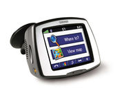
Garmin StreetPilot c580

$270.00 to $940.00


Receive door-to-door directions while staying on top of weather, traffic and localized information with the StreetPilot c580. Similar to the c550, StreetPilot c580 comes with hands-free calling, preloaded maps and an MP3 player, then takes it up a notch by adding dynamic content from MSN® Direct.

Manufacturer:Garmin Product MPNKey FeaturesDisplayTechnical FeaturesOther FeaturesGPS SystemPDA FeaturesBatteryWarrantyDimensionsMiscellaneous
MPN010-00522-06
GPS Type   Automobile
Form FactorFixed
Map capabilities   Internal, Download maps
Enhanced accuracyWAAS enabled, EGNOS enabled
Input Method   Touch Screen
Receiver Type18 Channels
Screen Size3.5 in.
Display Size2.8 in. x 2.1 in.
Display Type16-bit Color LCD TFT Display
Resolutions320 X 240
Special Features   MP3 Player, JPEG Image Viewer, 3D Map View
Trip calculator   Shortest time, Maximum speed, Current speed, Route Recalculation, Points-of-Interest (POI)
Included Software/Maps   North America Maps, Canada Maps, Europe Maps, Australia Maps, South Africa Maps, South America Maps, Middle East Maps, Great Britain
PC InterfaceUSB
Expansion Slot TypeSD (Secure Digital) Card Slot
AntennaBuilt-in, External Antenna Hookup
Accuisition Time - Cold38 sec
Accuisition Time - Initial Time1 sec
Update rate1 per second, continuous
Waypoints   500
Compatible PDA OSWindows 2000
Compatible DevicesNotebook
Battery Type and QuantityProprietary Li-Ion
Battery Life8 Hours
Warranty1 Year
Width4.4 in.
Depth2.2 in.
Height3.2 in.
Weight0.59 lb.
Family LineGarmin StreetPilot
UPC753759068004


Tags:

garmin, streetpilot, c580,

Garmin GPSMAP 440s

$437.00 to $1,032.00


Offshore fishermen and boaters will gravitate toward this sleek, space-saving chartplotter. The GPSMAP 440 features preloaded detailed maps for the U.S. coast as well as an ultra-bright 4” QVGA display; built-in, satellite-enhanced worldwide basemap and simplified user operation.

Manufacturer:Garmin Product MPNKey FeaturesDisplayTechnical FeaturesOther FeaturesGPS SystemWarrantyDimensionsMiscellaneous
MPN010-00516-44
GPS Type   Marine
Form FactorFixed
Map capabilities   Internal, Map cartridges / Data cards
Enhanced accuracyWAAS enabled, EGNOS enabled
Input Method   Keypad
Receiver Type12 Channels
Screen Size4 in.
Display Size2.4 in. x 3.2 in.
Display TypeLCD Display
Resolutions240 X 320
Marine FeaturesTide Prediction, Split Screen, Water Temp. Sensor, Depth Display, Chart Plotter, Sonar / Sounder, MOB (Man Over Board)
Audible Features   Anchor Alarm, Arrival Alarm, Clock Alarm, Accuracy Alarm, Fish Alarm, Shallow/Deep Alarm, Low Battary/Voltage Alarm, Water Temperature Alarm
Trip calculator   Route Recalculation, Trip Timers, Points-of-Interest (POI)
Included Software/Maps   Marine Cartography
PC InterfaceNMEA-0183
Environmental ProtectionIPX7 Waterproof Standard
Expansion Slot TypeSD (Secure Digital) Card Slot
AntennaBuilt-in, External Antenna Hookup
Accuisition Time - Cold45 sec
Accuisition Time - Initial Time15 sec
Update rate1 per second, continuous
Waypoints   1500
Warranty1 Year
Width5.7 in.
Depth2.7 in.
Height5 in.
Weight1.3 lb.
Family LineGarmin GPSMAP
UPC753759065836


Tags:

garmin, gpsmap, 440s,

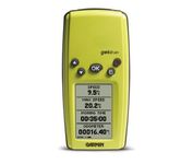
Garmin Geko 201

$90.00 to $140.00


With its distinctive canopy-green case, the powerful Geko 201 from Garmin(r) allows more waypoint and route storage, as well as available PC and external power connectivity, and built-in WAAS capability. In addition, the Geko 201 boasts a user-configurable trip computer, 10,000 trackpoints, a new upcoming-turn feature, as well as PanTrack(tm) and TracBack(r).Minimize

Manufacturer:Garmin Product MPNKey FeaturesDisplayTechnical FeaturesOther FeaturesGPS SystemBatteryWarrantyDimensionsMiscellaneous
MPN010-00318-00
GPS Type   Handheld (Outdoor)
Form FactorHandheld
Enhanced accuracyWAAS enabled
Input Method   Keypad
Receiver Type12 Channels
Screen Size1.7 in.
Display Size0.92 in. x 1.44 in.
Display Type4 Level Grayscale LCD Display
Resolutions64 X 100
Special Features   Waypoint Icons
Trip calculator   Maximum speed, Odometer, Current speed, Trip Timers, Time of sunrise/sunset, Track Log
Grids   Lat/Lon, MGRS, UTM, Maidenhead
PC InterfaceSerial RS-232, NMEA-0183
Environmental ProtectionIPX7 Waterproof Standard
AntennaBuilt-in
Accuisition Time - Cold45 sec
Accuisition Time - Initial Time15 sec
Update rate1 per second, continuous
Max. Horizontal accuracy   Enhanced position accuracy Differential standardsDGPS Ready
Number of routes20
Waypoints   500
Battery Type and Quantity2 x AAA Batteries
Battery Life12 Hours
Warranty1 Year
Width1.9 in.
Depth0.96 in.
Height3.9 in.
Weight0.14 lb.
Family LineGarmin Geko
UPC753759042066


Tags:

garmin, geko, 201,


Garmin nuvi 250


Packed with features and available in a variety of hip colors, the Garmin nuvi 250 is affordably priced and easy to use. The nuvi 250 comes preloaded with City Navigator map data giving you quick, turn-by-turn directions to anywhere in the continental United States. Pull up colorful, 2-D or 3-D maps on the sunlight-readable screen and voice directions will guide you safely and quickly to your selected destination. You can also set custom points of interest on the nuvi 250 such as your favorite restaurants or coffee shops, and with proximity alerts you’re always aware of where you’re going, and where you’ve been.Minimize


Garmin nuvi 255W


Go wide and get peace of mind with nuvi 255W. This affordable, widescreen navigator leads the way with voice-prompted turn-by-turn directions that speak street names and optional MSN Direct® services to get you there on time and keep you informed. It's packed with millions of destinations and maps for North America or Europe. Like the rest of the sleek nüvi 2x5-series, this portable navigator is priced right and ultra-easy to use.Minimize


Furuno GP7000F NT


The GP-7000F/NT is a GPS/WAAS plotter designed for a variety of vessels desiring video plotting and echo sounding capabilities. With the GP-7000 series, you can see the highly accurate position of your boat on the chart. The GP-7000 series has four display modes: Course Plot, Nav Data, Steering, and Highway modes. The course plot mode is useful for obtaining general information about surrounding sea areas. The Nav data mode clearly shows important navigational information with large text, which is easy to see even from a distance. The steering mode and highway mode assist the operator in following a predetermined route.Minimize


Navman NavPix N40i


The N40i includes an integrated digital camera for taking NavPix to create an unmistakeable reminder of your chosen destination. So you can find your way there - no matter how far away it is – whenever you want.