Garmin StreetPilot i5$181.00 to $450.00

It may be tiny, but the StreetPilot i5 is packed with state-of-the-art navigation features. The StreetPilot i5 comes preloaded with incredibly detailed City Navigator NT street maps that are packed with nearly 6 million points of interest including hotels, restaurants, ATMs and much more. A simple rolling-wheel interface allows you to quickly adjust settings and alter routes to your destination. Built for portability and power, the StreetPilot i5 is a cost effective portable GPS solution. Minimize
Manufacturer:Garmin Product MPN MPN | SPI5 | Key Features GPS Type | Automobile | Form Factor | Handheld | Enhanced accuracy | WAAS enabled | Receiver Type | 12 Channels | Screen Size | 2.1 in. | Display Display Size | 1.7 in. x 1.3 in. | Display Type | 32k Colors LCD TFT Display | Resolutions | 220 x 176 | Technical Features Audible Features | Voice Navigation Instructions | Trip calculator | Detour Feature, Points-of-Interest (POI) | Other Features PC Interface | USB | Battery Battery Type and Quantity | 2 x AA Batteries | Battery Life | 7 Hours | Dimensions Width | 3 in. | Depth | 2.15 in. | Height | 2.74 in. | Weight | 0.32 lb. | Miscellaneous Family Line | Garmin StreetPilot | UPC | 840356505404 |
Tags:garmin, streetpilot, i5,
| Bushnell NAV500$164.00 to $285.00
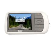
Bushnell has announced their entry into the portable auto GPS navigation market with the announcement of the Bushnell Nav 500. The Nav 500 offers many features found on other navigation devices in its class such as a 3.5 inch touch screen display, pre-installed maps of the USA and Canada, and an MP3 player.
Manufacturer:Bushnell Product MPN MPN | 36-5001 | Key Features GPS Type | Automobile | Form Factor | Fixed | Map capabilities | Internal, Map cartridges / Data cards, DVD | Enhanced accuracy | WAAS enabled | Input Method | Keypad, Touch Screen | Receiver Type | 20 Channels | Display Display Size | 3.5 in. | Display Type | LCD Display | Resolutions | 320 X 240 | Technical Features Marine Features | Split Screen | Special Features | Compass, MP3 Player | Audible Features | Voice Navigation Instructions | Trip calculator | Route Recalculation | Included Software/Maps | Canada Maps | Grids | Lat/Lon | Other Features PC Interface | USB, Bluetooth | Expansion Slot Type | SD (Secure Digital) Card Slot | Battery Battery Type and Quantity | Rechargeable Li-Ion Battery | Warranty Warranty | 1 Year | Dimensions Width | 5.63 in. | Depth | 0.91 in. | Height | 3 in. | Weight | 0.75 lb. | Miscellaneous UPC | 029757365002 |
Tags:bushnell, nav500,
| Dual Electronics XNAV3550$219.00 to $228.00

The Dual XNA3550 features an easy to use touch screen graphic interface with MP3 playback capability. Turn-by-turn instructions with voice guidance. Visual left/right LED indicators. 3D Map view. Level selectable map view. Start route guidance search by:- Address/intersection- Points of interest- Address book- Recent destination. GPS status indicator.Minimize
Manufacturer:Dual Electronics Product MPN MPN | XNAV3550 | Key Features GPS Type | Automobile | Form Factor | Fixed | Map capabilities | Internal | Input Method | Touch Screen | Receiver Type | 12 Channels | Display Display Size | 3.5 in. | Display Type | 16.7M Colors LCD TFT Display | Resolutions | 320 X 240 | Technical Features Special Features | Address Book, MP3 Player, 3D Map View | Trip calculator | Route Recalculation, Points-of-Interest (POI) | Included Software/Maps | USA Maps | Other Features Built in memory | 64 MB | Expansion Slot Type | SD (Secure Digital) Card Slot | Antenna | Built-in | PDA Features Plug-in Interface | Secure Digital (SD) | Compatible PDA OS | Windows CE | Battery Battery Type and Quantity | Rechargeable Li-Ion Battery | Battery Life | 2 Hours | Dimensions Width | 5.25 in. | Depth | 1.25 in. | Height | 3.13 in. | Weight | 2.1 lb. | Miscellaneous UPC | 827204101636 |
Tags:dual, electronics, xnav3550,
|

Get moving with TomTom Navigator 3. The flexible and personal car navigation system works on your Pocket PC. TomTom Navigator 3 guides you effortlessly from door to door via the best route. Clear 3D colour maps and spoken instructions take the stress out of driving. Plan the best route when you have multiple stops: pick up colleagues on the way to a meeting or friends on the way to a restaurant. Route around areas you would like to avoid due to traffic jams or road works. The Major Roads of Europe feature makes planning and navigating international trips easier than ever. Plan the best route from Munich to Lyon, and TomTom will guide you there.Minimize

The GP-7000F/NT is a GPS/WAAS plotter designed for a variety of vessels desiring video plotting and echo sounding capabilities. With the GP-7000 series, you can see the highly accurate position of your boat on the chart. The GP-7000 series has four display modes: Course Plot, Nav Data, Steering, and Highway modes. The course plot mode is useful for obtaining general information about surrounding sea areas. The Nav data mode clearly shows important navigational information with large text, which is easy to see even from a distance. The steering mode and highway mode assist the operator in following a predetermined route.Minimize
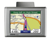
Sleek and portable, the Garmin nuvi 350 comes preloaded with City Navigator NT street maps that highlight countless points of interest including hotels, restaurants, gas stations, ATMs and much more. A simple touch-screen interface allows you to quickly pull up 2-D or 3-D maps, and with turn-by-turn voice directions, you’ll never have to take your eyes off the road to get your bearings. The nuvi 350 also includes MP3 playback, a JPEG picture viewer, currency converters, and a host of other travel handy applications.Minimize
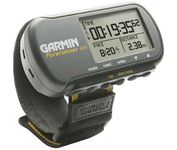
The Forerunner 101 offers athletes and recreational walkers and runners an entry-level personal training device with GPS. It has the same features as the Forerunner 201, but operates on two AAA batteries. The Forerunner 101 stores lap histories for up to two years to provide an archive of workout performance over time. Users can retrieve lap data for previous workouts by date, week, month, or over a specific time interval. For business travelers who want to train on the road, the Forerunner 101 also doubles as a navigator. Users can mark their hotel as a specific location, see their current position on the plotter display, and follow an electronic breadcrumb trail back to their starting point.Minimize