Dual Electronics XNAV3550$219.00 to $228.00

The Dual XNA3550 features an easy to use touch screen graphic interface with MP3 playback capability. Turn-by-turn instructions with voice guidance. Visual left/right LED indicators. 3D Map view. Level selectable map view. Start route guidance search by:- Address/intersection- Points of interest- Address book- Recent destination. GPS status indicator.Minimize
Manufacturer:Dual Electronics Product MPN MPN | XNAV3550 | Key Features GPS Type | Automobile | Form Factor | Fixed | Map capabilities | Internal | Input Method | Touch Screen | Receiver Type | 12 Channels | Display Display Size | 3.5 in. | Display Type | 16.7M Colors LCD TFT Display | Resolutions | 320 X 240 | Technical Features Special Features | Address Book, MP3 Player, 3D Map View | Trip calculator | Route Recalculation, Points-of-Interest (POI) | Included Software/Maps | USA Maps | Other Features Built in memory | 64 MB | Expansion Slot Type | SD (Secure Digital) Card Slot | Antenna | Built-in | PDA Features Plug-in Interface | Secure Digital (SD) | Compatible PDA OS | Windows CE | Battery Battery Type and Quantity | Rechargeable Li-Ion Battery | Battery Life | 2 Hours | Dimensions Width | 5.25 in. | Depth | 1.25 in. | Height | 3.13 in. | Weight | 2.1 lb. | Miscellaneous UPC | 827204101636 |
Tags:dual, electronics, xnav3550,
| Lowrance iFINDER GO2$150.00 to $225.00
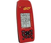
Just grab this bright yellow handheld iFINDER Go 64MB GPS and go, go, go. It's easy to use, waterproof, has a 2.2 diagonal Film SuperTwist display with backlighting and a built-in 64MB background map with coverage of the continental U.S. and Hawaii. The GPS also includes up to 1,000 waypoints, 1,000 event markers and 100 routes; up to 100 retraceable plot trails and up to 10,000 points in any trail; 30+ map zoom ranges and 42 graphic icons to mark spots.Minimize
Manufacturer:Lowrance Product MPN MPN | 112-49 | Key Features GPS Type | Handheld (Outdoor) | Form Factor | Handheld | Map capabilities | Internal | Enhanced accuracy | WAAS enabled | Input Method | Keypad | Receiver Type | 16 Channels | Display Display Size | 2 in. | Display Type | 16 Level Grayscale Display | Resolutions | 200 X 140 | Technical Features Marine Features | MOB (Man Over Board) | Special Features | Waypoint Icons | Included Software/Maps | USA Maps | Other Features Built in memory | 64 MB | Environmental Protection | IPX7 Waterproof Standard | GPS System Number of routes | 100 | Waypoints | 1000 | Battery Battery Type and Quantity | 2 x AA Batteries | Battery Life | 48 Hours | Warranty Warranty | 1 Year | Dimensions Width | 2.12 in. | Depth | 1.24 in. | Height | 5.15 in. | Weight | 0.34 lb. | Miscellaneous Family Line | Lowrance iFINDER | UPC | 042194525426 |
Tags:lowrance, ifinder, go2,
| Garmin Rino 130$265.00 to $455.00
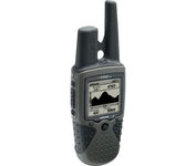
The Rino 130 is the most feature-rich unit in the Rino family with a built-in electronic compass barometric sensor weather receiver for seven NOAA weather channels and 24 MBs of internal memory This handheld radio has a built-in electronic compass to give a heading while the user is standing still and a barometric altimeter to provide extremely accurate elevation and pressure information which will assist users in identifying weather data The Rino 130 provides two-way radio communication with a transmission range of up to two miles using FRS channels and up to five miles with GMRS The integration of two-way radio and GPS enables users to transmit their position with a simple button press allowing others to navigate to their position The Rino 130 also has a polling feature which allows a user to manually request GPS location information from other Rino unitsMinimize
Manufacturer:Garmin Product MPN MPN | 010-00270-23 | Key Features GPS Type | Unknown Form Factor | Handheld | Map capabilities | Internal, Download maps | Enhanced accuracy | WAAS enabled | Receiver Type | 12 Channels | Screen Size | 2 in. | Display Display Size | 1.4 in. x 1.4 in. | Display Type | LCD Display | Resolutions | 160 X 160 | Technical Features Special Features | Waypoint Icons, Compass, Built-In Altimeter | Audible Features | Proximity Alarm | Trip calculator | Maximum speed, Current speed | Included Software/Maps | Marine Cartography, North America Maps | Grids | Lat/Lon, MGRS, UTM, Loran TD position format, Maidenhead | Other Features PC Interface | Serial RS-232, NMEA-0183 | Built in memory | 24 MB | Environmental Protection | IPX7 Waterproof Standard | Antenna | Quadrifilar Helix | GPS System Accuisition Time - Cold | 45 sec | Accuisition Time - Initial Time | 15 sec | Update rate | 1 per second, continuous | Max. Horizontal accuracy | | Enhanced position accuracy | | Differential standards | DGPS Ready | Number of routes | 20 | Waypoints | 500 | Battery Battery Type and Quantity | 3 x AA Batteries | Battery Life | 28 Hours | Warranty Warranty | 1 Year | Dimensions Width | 2.3 in. | Depth | 1.6 in. | Height | 4.5 in. | Weight | 0.48 lb. | Miscellaneous Family Line | Garmin Rino | UPC | 753759031978 |
Tags:garmin, rino, 130,
|
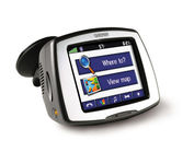
Receive door-to-door directions while staying on top of weather, traffic and localized information with the StreetPilot c580. Similar to the c550, StreetPilot c580 comes with hands-free calling, preloaded maps and an MP3 player, then takes it up a notch by adding dynamic content from MSN® Direct.
The handheld mapping GPS designed by hunters for hunters lets you follow the big game in color with 16-channel GPS precision. The iFINDER® Hunt C with color display offers everything you'd expect in a versatile, precision mapping GPS unit made for the field, including hunting-specific icons, unique "Scout Mode", electronic compass, barometric altimeter, built-in microphone, and more.Minimize
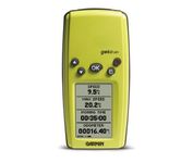
With its distinctive canopy-green case, the powerful Geko 201 from Garmin(r) allows more waypoint and route storage, as well as available PC and external power connectivity, and built-in WAAS capability. In addition, the Geko 201 boasts a user-configurable trip computer, 10,000 trackpoints, a new upcoming-turn feature, as well as PanTrack(tm) and TracBack(r).Minimize

This preloaded, offshore chartplotter combines the power of networking with brilliant color and slim-line design. The GPSMAP 4212 has preloaded BlueChart® g2 maps of the U.S. coast and displays them on a whopping 12.1” XGA display with crisp, video-quality resolution. By connecting to the Garmin Marine Network, you can add sonar, radar and weather. For even more enhanced features, you can add the optional Bluechart g2 Vision card.Minimize