Products reviews

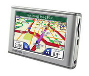
Garmin nuvi 650

$150.00 to $419.00


The Garmin nuvi 650 isn’t just a portable GPS system; it’s a fully featured multimedia device capable of MP3 playback and JPEG picture viewing. The nuvi 650 comes preloaded with City Navigator NT street maps that are loaded with hundreds of useful points of interest including gas stations, restaurants, and movie theaters. The touch screen interface gives you quick and easy access the nuvi 650’s many functions, and with the slim, sleek design you can easily stow it in your purse, backpack, or pocket. A rechargeable lithium-ion battery makes it suitable for navigation while in the car or even on foot.Minimize

Manufacturer:Garmin Product MPNKey FeaturesDisplayTechnical FeaturesOther FeaturesBatteryWarrantyDimensionsMiscellaneous
MPN010-00540-70
GPS Type   Automobile
Form FactorFixed
Map capabilities   Map cartridges / Data cards, Download maps
Enhanced accuracyWAAS enabled
Input Method   Touch Screen
Screen Size4.4 in.
Display Size3.81 in. x 2.25 in.
Display TypeLCD TFT Display
Resolutions480 x 272
Special Features   MP3 Player, Audio Book Player, JPEG Image Viewer, Converter, Calculator, 3D Map View
Audible Features   Proximity Alarm, Voice Navigation Instructions
Trip calculator   Detour Feature, Points-of-Interest (POI)
Included Software/Maps   North America Maps, USA Maps, Europe Maps
PC InterfaceUSB
Expansion Slot TypeSD (Secure Digital) Card Slot
AntennaFlip-up
Battery Type and QuantityRechargeable Li-Ion Battery
Battery Life7 Hours
Warranty1 Year
Width4.9 in.
Depth0.9 in.
Height2.9 in.
Weight0.39 lb.
Family LineGarmin nuvi
UPC718122378609


Tags:

garmin, nuvi, 650,

Pharos Science PF080

$89.00 to $241.00


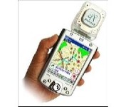
Pharos, the leader in advanced, affordable navigation solutions for handheld computing, has created the ultimate navigation tool for Windows Mobile-based Pocket PCs and mobile devices. Use Pharos Pocket GPS Navigator with CompactFlash to navigate door-to-door or point-to-point. Use it for hiking, walking tours or other outdoor activities. With audio voice prompts to guide you to your destination, the Pocket GPS Navigator is great for your car, too. In fact, the Pharos GPS Navigator performs just like more expensive, factory-installed, in-vehicle navigation systems, at a fraction of the cost yet, its easy to load into your Pocket PC and simple to use.Minimize

Manufacturer:Pharos Science Product MPNKey FeaturesTechnical FeaturesOther FeaturesGPS SystemDimensionsMiscellaneous
MPNpf080
GPS Type   Automobile
Form FactorHandheld
Map capabilities   Download maps
Enhanced accuracyWAAS enabled, EGNOS enabled
Receiver Type12 Channels
Special Features   Compass
Audible Features   Voice Navigation Instructions
Trip calculator   Real-time Traffic Reports, Points-of-Interest (POI)
PC InterfaceNMEA-0183
Expansion Slot TypeCompact Flash (CF)
AntennaBuilt-in
Accuisition Time - Cold60 sec
Accuisition Time - Initial Time40 sec
Accuisition Time - Hot5 sec
Update rate1 per second, continuous
Max. Horizontal accuracy   PDA Features
Plug-in Interface   Compact Flash (CF)
Width1.93 in.
Depth0.63 in.
Height2.17 in.
Weight0.09 lb.
UPC818948001030


Tags:

pharos, science, pf080,

Garmin StreetPilot c530

$180.00


StreetPilot c530 comes ready to go right out of the box with preloaded City Navigator® NT street maps and a hefty points of interest (POIs) database, including motels, restaurants, fuel, ATMs and more. Simply touch the super-bright sunlight-readable color screen to enter a destination, and the c530 takes you there with 2D or 3D maps and turn-by-turn voice directions. In addition, the c530 accepts custom points of interest (POIs) such as school zones and safety cameras and lets you set proximity alerts to warn you of upcoming POIs.Minimize

Manufacturer:Garmin Product MPNKey FeaturesDisplayTechnical FeaturesOther FeaturesGPS SystemPDA FeaturesBatteryDimensionsMiscellaneous
MPNSTREETC530
GPS Type   Automobile
Form FactorFixed
Map capabilities   Internal, Map cartridges / Data cards
Input Method   Touch Screen
Screen Size3.5 in.
Display Size2.8 in. x 2.1 in.
Display TypeLCD TFT Display
Resolutions320 X 240
Special Features   Audio Book Player
Trip calculator   Shortest time, Shortest distance, Route Recalculation, Avoid toll roads
Included Software/Maps   North America Maps
PC InterfaceUSB, Bluetooth
Expansion Slot TypeSD (Secure Digital) Card Slot
Waypoints   500
Plug-in Interface   Secure Digital (SD)
Compatible PDA OSWindows 2000
Compatible DevicesNotebook
Battery Type and QuantityRechargeable Li-Ion Battery
Battery Life8 Hours
Width4.4 in.
Depth2.25 in.
Height3.2 in.
Weight0.56 lb.
Family LineGarmin StreetPilot
UPC053759054473


Tags:

garmin, streetpilot, c530,


Garmin eTrex Summit


The eTrex Summit comes on the heels of the extremely popular eTrex, which was designed for both marine and recreation use. This new all-in-one navigation device for the outdoor enthusiast is the first combination GPS, altimeter, and electronic compass. The electronic compass provides bearing information when you're standing still and the altimeter determines precise altitude, so you can tell how high you've climbed and your rate of ascent. Like its predecessor, the eTrex Summit boasts a powerful 12 parallel channel GPS receiver and comes packaged in a small, sleek case with operating buttons located on either side of the unit. The case is completely waterproof to withstand immersion in one meter of water for up to 30 minutes.Minimize


Garmin GPS 76


The GPS 76 is designed to provide precise GPS positioning using correction data obtained from the Wide Area Augmentation System (WAAS). This unit features a built-in quad helix antenna for superior reception and can provide position accuracy to less than three meters when receiving WAAS corrections.The GPS 76 provides 1 megabyte of internal user memory to be used for storing downloaded Points of Interest data. This 1 megabyte of storage area is preloaded from the factory with worldwide cities (populations greater than 200,000) and nautical navigation aids such as lights, buoys, sound signals and day beacons, and is perfect for downloading points of interest detail from GARMIN's line of MapSource CD-ROMs. The GPS 76 is also preloaded with tide data for the United States.Minimize


Magellan Maestro 3100
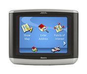

Magellan Maestro 3100 offers simple, sophisticated GPS navigation that's remarkably affordable. The most intuitive graphical 3.5" touch-screen interface available makes navigation easy. Enter virtually any destination and get turn-by-turn voice guidance to locations all over the contiguous United States. Smart touch-icons and Magellan's unique QuickSpell function enable error-free spelling, minimizing steps, so you get a customized route to your destination with just a few touches of the screen. Hundreds of thousands of preprogrammed points of interest make it easy to find restaurants, gas stations, ATM and more. Minimize


TomTom Navigator 3


Get moving with TomTom Navigator 3. The flexible and personal car navigation system works on your Pocket PC. TomTom Navigator 3 guides you effortlessly from door to door via the best route. Clear 3D colour maps and spoken instructions take the stress out of driving. Plan the best route when you have multiple stops: pick up colleagues on the way to a meeting or friends on the way to a restaurant. Route around areas you would like to avoid due to traffic jams or road works. The Major Roads of Europe feature makes planning and navigating international trips easier than ever. Plan the best route from Munich to Lyon, and TomTom will guide you there.Minimize