Garmin GPS 72$190.00

The GPS 72 is a low-cost solution for land or marine navigation designed to provide precise GPS positioning using correction data obtained from the Wide Area Augmentation System (WAAS). The GPS 72 can provide position accuracy to less than three meters when receiving WAAS corrections. This rugged, waterproof, unsinkable GPS receiver offers a large, 4-level grayscale screen. It's designed as the next generation in basic, entry-level GARMIN GPS.Minimize
Manufacturer:Garmin Product MPN MPN | 010-00309-00 | Key Features GPS Type | Marine | Form Factor | Handheld | Map capabilities | Internal, Download maps | Enhanced accuracy | WAAS enabled | Input Method | Keypad | Receiver Type | 12 Channels | Screen Size | 2.7 in. | Display Display Size | 1.6 in. x 2.2 in. | Display Type | 4 Level Grayscale Display | Resolutions | 120 X 160 | Technical Features Audible Features | Proximity Alarm, Anchor Alarm, Arrival Alarm, Off-Course Alarm, Shallow/Deep Alarm | Trip calculator | Moving average, Total average, Maximum speed, Points-of-Interest (POI) | Included Software/Maps | Marine Cartography, City Navigation Maps | Grids | Lat/Lon, MGRS, User Grid, UTM, Loran TD position format, Maidenhead | Other Features PC Interface | Serial RS-232 | Built in memory | 1 MB | Environmental Protection | IPX7 Waterproof Standard, High Impact Plastic Alloy Body | Antenna | Quadrifilar Helix | GPS System Accuisition Time - Cold | 45 sec | Accuisition Time - Initial Time | 15 sec | Update rate | 1 per second, continuous | Max. Horizontal accuracy | | Enhanced position accuracy | | Differential standards | DGPS Ready | Number of routes | 50 | Waypoints | 500 | Battery Battery Type and Quantity | 2 x AA Batteries | Battery Life | 16 Hours | Warranty Warranty | 1 Year | Dimensions Width | 2.7 in. | Depth | 1.2 in. | Height | 6.2 in. | Weight | 0.48 lb. | Miscellaneous Family Line | Garmin GPS | UPC | 753759041540 |
Tags:garmin, gps, 72,
| Lowrance M68C$394.00 to $526.00
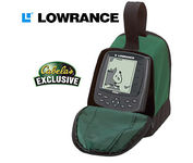
Combining the 256-color technology of the sonar industry and the superior precision of Lowrance GPS units, the M-68c sonar/map gives you all the capabilities of the extreme high-end combo units in a smaller, more affordable package. Features a full 12-parallel channel GPS and WAAS receiver and 40 map ranges from .02 to 4,000 miles with easy zoom. The high-bright 3.5" diagonal TFT active matrix transflective display delivers a wide viewing angle and superb readability in direct sunlight. And, it includes an advanced LED screen and keypad backlighting for night and low-light operation.Minimize
Manufacturer:Lowrance Product MPN MPN | 3842201200 | Key Features GPS Type | Marine | Form Factor | Fixed | Map capabilities | Internal | Enhanced accuracy | WAAS enabled | Input Method | Keypad | Receiver Type | 12 Channels | Display Display Size | 3.5 in. | Display Type | 256 Color LCD TFT Display | Resolutions | 320 X 240 | Technical Features Marine Features | Fish Finder, Split Screen, MOB (Man Over Board) | Special Features | Waypoint Icons | Audible Features | Proximity Alarm, Anchor Alarm, Arrival Alarm, Off-Course Alarm, Fish Alarm, Shallow/Deep Alarm | Trip calculator | Trip Timers, Time of sunrise/sunset | Other Features Antenna | Built-in | GPS System Number of routes | 100 | Waypoints | 1000 | Warranty Warranty | 1 Year | Dimensions Width | 4.23 in. | Depth | 3.26 in. | Height | 6.26 in. |
Tags:lowrance, m68c,
| Garmin GPS 18$48.00 to $169.00
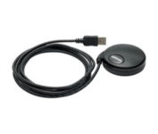
Turn your laptop PC into a powerful street navigator with the GPS 18 a GPS sensor bundled with nRoute and City Select software that automatically guides you with turn-by-turn directions and voice prompts to get you safely to your destination.
Manufacturer:Garmin Product MPN MPN | 010-00321-54 | Key Features GPS Type | Handheld (Outdoor) | Form Factor | Handheld, Plug-in | Map capabilities | Download maps | Enhanced accuracy | WAAS enabled | Receiver Type | 12 Channels | Technical Features Audible Features | Voice Navigation Instructions | Trip calculator | Points-of-Interest (POI) | Included Software/Maps | North America Maps, Europe Maps, South America Maps | Other Features PC Interface | USB 2.0, USB | GPS System Accuisition Time - Cold | 45 sec | Accuisition Time - Initial Time | 15 sec | Update rate | 1 per second, continuous | Max. Horizontal accuracy | | Enhanced position accuracy | | Differential standards | DGPS Ready | Warranty Warranty | 1 Year | Dimensions Width | 2.4 in. | Depth | 2.4 in. | Height | 0.77 in. | Weight | 0.22 lb. | Miscellaneous Family Line | Garmin GPS | UPC | 753759042714 |
Tags:garmin, gps, 18,
|

No matter where your outdoor activities take you, the Rino® 530 keeps you on track and in touch. Similar to the 520, this rugged, two-way radio with GPS packs a bold color display, 14-mile communication range, and turn-by-turn directions - giving you peace of mind in the great outdoors. Taking it a step further, the Rino 530 adds an electronic compass, barometric altimeter, and NOAA weather receiver, making it a favorite with hikers and climbers.Minimize
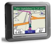
Packed with features and available in a variety of hip colors, the Garmin nuvi 250 is affordably priced and easy to use. The nuvi 250 comes preloaded with City Navigator map data giving you quick, turn-by-turn directions to anywhere in the continental United States. Pull up colorful, 2-D or 3-D maps on the sunlight-readable screen and voice directions will guide you safely and quickly to your selected destination. You can also set custom points of interest on the nuvi 250 such as your favorite restaurants or coffee shops, and with proximity alerts you’re always aware of where you’re going, and where you’ve been.Minimize

Rugged, lightweight Edge attaches easily to the stem or handlebars of your bike with the included bike mount. Just turn it on, acquire GPS satellites and go. Edge 305 automatically measures your speed, distance, time, calories burned, altitude, climb and descent, and also records the route you have taken for review. For extra-precise climb and descent data, Edge 305 also incorporates a barometric altimeter to pinpoint changes in elevation.Minimize
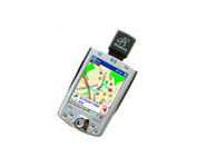
The Pharos Pocket GPS Navigator is an excellent navigation solution for your Dell Pocket PC. The package comes with a compact iGPS-SD receiver and the Ostia Smart Navigator software with detailed street-level maps of entire US. It even includes a car charger that powers the GPS while charging your Pocket PC simultaneously. The iGPS-SD receiver is a small, slim and sensitive GPS receiver that plugs in the Pocket PC's SDIO slot. Ostia helps you locate your current position, find a destination or point of interest (POI) and get a route to your destination. Simply activate the GPS navigation program and begin traveling; the automated voice-prompts will tell you when and where to turn. If by chance you go 'off route', the Pocket GPS Navigator will always reroute you to your destination from your current GPS position.Minimize