Products reviews

Garmin GPS 72

$190.00


The GPS 72 is a low-cost solution for land or marine navigation designed to provide precise GPS positioning using correction data obtained from the Wide Area Augmentation System (WAAS). The GPS 72 can provide position accuracy to less than three meters when receiving WAAS corrections. This rugged, waterproof, unsinkable GPS receiver offers a large, 4-level grayscale screen. It's designed as the next generation in basic, entry-level GARMIN GPS.Minimize

Manufacturer:Garmin Product MPNKey FeaturesDisplayTechnical FeaturesOther FeaturesGPS SystemBatteryWarrantyDimensionsMiscellaneous
MPN010-00309-00
GPS Type   Marine
Form FactorHandheld
Map capabilities   Internal, Download maps
Enhanced accuracyWAAS enabled
Input Method   Keypad
Receiver Type12 Channels
Screen Size2.7 in.
Display Size1.6 in. x 2.2 in.
Display Type4 Level Grayscale Display
Resolutions120 X 160
Audible Features   Proximity Alarm, Anchor Alarm, Arrival Alarm, Off-Course Alarm, Shallow/Deep Alarm
Trip calculator   Moving average, Total average, Maximum speed, Points-of-Interest (POI)
Included Software/Maps   Marine Cartography, City Navigation Maps
Grids   Lat/Lon, MGRS, User Grid, UTM, Loran TD position format, Maidenhead
PC InterfaceSerial RS-232
Built in memory1 MB
Environmental ProtectionIPX7 Waterproof Standard, High Impact Plastic Alloy Body
AntennaQuadrifilar Helix
Accuisition Time - Cold45 sec
Accuisition Time - Initial Time15 sec
Update rate1 per second, continuous
Max. Horizontal accuracy   Enhanced position accuracy Differential standardsDGPS Ready
Number of routes50
Waypoints   500
Battery Type and Quantity2 x AA Batteries
Battery Life16 Hours
Warranty1 Year
Width2.7 in.
Depth1.2 in.
Height6.2 in.
Weight0.48 lb.
Family LineGarmin GPS
UPC753759041540


Tags:

garmin, gps, 72,

Lowrance iFINDER GO2

$150.00 to $225.00


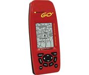
Just grab this bright yellow handheld iFINDER Go 64MB GPS and go, go, go. It's easy to use, waterproof, has a 2.2 diagonal Film SuperTwist display with backlighting and a built-in 64MB background map with coverage of the continental U.S. and Hawaii. The GPS also includes up to 1,000 waypoints, 1,000 event markers and 100 routes; up to 100 retraceable plot trails and up to 10,000 points in any trail; 30+ map zoom ranges and 42 graphic icons to mark spots.Minimize

Manufacturer:Lowrance Product MPNKey FeaturesDisplayTechnical FeaturesOther FeaturesGPS SystemBatteryWarrantyDimensionsMiscellaneous
MPN112-49
GPS Type   Handheld (Outdoor)
Form FactorHandheld
Map capabilities   Internal
Enhanced accuracyWAAS enabled
Input Method   Keypad
Receiver Type16 Channels
Display Size2 in.
Display Type16 Level Grayscale Display
Resolutions200 X 140
Marine FeaturesMOB (Man Over Board)
Special Features   Waypoint Icons
Included Software/Maps   USA Maps
Built in memory64 MB
Environmental ProtectionIPX7 Waterproof Standard
Number of routes100
Waypoints   1000
Battery Type and Quantity2 x AA Batteries
Battery Life48 Hours
Warranty1 Year
Width2.12 in.
Depth1.24 in.
Height5.15 in.
Weight0.34 lb.
Family LineLowrance iFINDER
UPC042194525426


Tags:

lowrance, ifinder, go2,

GlobalSat BT-359

$40.00 to $90.00


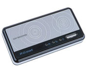
The GlobalSat BT-359 Bluetooth GPS receiver is our solution of the line Bluetooth GPS, which have both stylish and functional in true GlobalSat tradition. Taking its design criteria from the market leading BT-338 we have pushed the limits of GPS even further with greater sensitivity, more accuracy, and longer battery life than ever beforeMinimize

Manufacturer:GlobalSat Product MPNKey FeaturesOther FeaturesGPS SystemDimensionsMiscellaneous
MPNBT-359
GPS Type   Handheld (Outdoor)
Form FactorWireless Receiver Module
Enhanced accuracyWAAS enabled, EGNOS enabled
Receiver Type20 Channels
PC InterfaceNMEA-0183, Bluetooth
AntennaBuilt-in
Accuisition Time - Cold42 sec
Accuisition Time - Initial Time38 sec
Accuisition Time - Hot1 sec
Max. Horizontal accuracy   Battery
Battery Type and QuantityProprietary Lithium
Battery Life11 Hours
Width3.23 in.
Depth0.53 in.
Height1.61 in.
UPC4043619603046


Tags:

globalsat, bt-359,


Furuno GP7000F NT


The GP-7000F/NT is a GPS/WAAS plotter designed for a variety of vessels desiring video plotting and echo sounding capabilities. With the GP-7000 series, you can see the highly accurate position of your boat on the chart. The GP-7000 series has four display modes: Course Plot, Nav Data, Steering, and Highway modes. The course plot mode is useful for obtaining general information about surrounding sea areas. The Nav data mode clearly shows important navigational information with large text, which is easy to see even from a distance. The steering mode and highway mode assist the operator in following a predetermined route.Minimize


Garmin nuvi 650
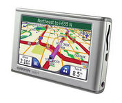

The Garmin nuvi 650 isn’t just a portable GPS system; it’s a fully featured multimedia device capable of MP3 playback and JPEG picture viewing. The nuvi 650 comes preloaded with City Navigator NT street maps that are loaded with hundreds of useful points of interest including gas stations, restaurants, and movie theaters. The touch screen interface gives you quick and easy access the nuvi 650’s many functions, and with the slim, sleek design you can easily stow it in your purse, backpack, or pocket. A rechargeable lithium-ion battery makes it suitable for navigation while in the car or even on foot.Minimize


Garmin Rino 530


No matter where your outdoor activities take you, the Rino® 530 keeps you on track and in touch. Similar to the 520, this rugged, two-way radio with GPS packs a bold color display, 14-mile communication range, and turn-by-turn directions - giving you peace of mind in the great outdoors. Taking it a step further, the Rino 530 adds an electronic compass, barometric altimeter, and NOAA weather receiver, making it a favorite with hikers and climbers.Minimize


Garmin Rino 130
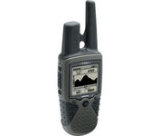

The Rino 130 is the most feature-rich unit in the Rino family with a built-in electronic compass barometric sensor weather receiver for seven NOAA weather channels and 24 MBs of internal memory This handheld radio has a built-in electronic compass to give a heading while the user is standing still and a barometric altimeter to provide extremely accurate elevation and pressure information which will assist users in identifying weather data The Rino 130 provides two-way radio communication with a transmission range of up to two miles using FRS channels and up to five miles with GMRS The integration of two-way radio and GPS enables users to transmit their position with a simple button press allowing others to navigate to their position The Rino 130 also has a polling feature which allows a user to manually request GPS location information from other Rino unitsMinimize