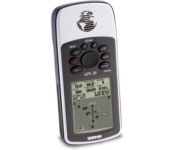
Garmin GPS 72$190.00

The GPS 72 is a low-cost solution for land or marine navigation designed to provide precise GPS positioning using correction data obtained from the Wide Area Augmentation System (WAAS). The GPS 72 can provide position accuracy to less than three meters when receiving WAAS corrections. This rugged, waterproof, unsinkable GPS receiver offers a large, 4-level grayscale screen. It's designed as the next generation in basic, entry-level GARMIN GPS.Minimize
Manufacturer:Garmin Product MPN MPN | 010-00309-00 | Key Features GPS Type | Marine | Form Factor | Handheld | Map capabilities | Internal, Download maps | Enhanced accuracy | WAAS enabled | Input Method | Keypad | Receiver Type | 12 Channels | Screen Size | 2.7 in. | Display Display Size | 1.6 in. x 2.2 in. | Display Type | 4 Level Grayscale Display | Resolutions | 120 X 160 | Technical Features Audible Features | Proximity Alarm, Anchor Alarm, Arrival Alarm, Off-Course Alarm, Shallow/Deep Alarm | Trip calculator | Moving average, Total average, Maximum speed, Points-of-Interest (POI) | Included Software/Maps | Marine Cartography, City Navigation Maps | Grids | Lat/Lon, MGRS, User Grid, UTM, Loran TD position format, Maidenhead | Other Features PC Interface | Serial RS-232 | Built in memory | 1 MB | Environmental Protection | IPX7 Waterproof Standard, High Impact Plastic Alloy Body | Antenna | Quadrifilar Helix | GPS System Accuisition Time - Cold | 45 sec | Accuisition Time - Initial Time | 15 sec | Update rate | 1 per second, continuous | Max. Horizontal accuracy | | Enhanced position accuracy | | Differential standards | DGPS Ready | Number of routes | 50 | Waypoints | 500 | Battery Battery Type and Quantity | 2 x AA Batteries | Battery Life | 16 Hours | Warranty Warranty | 1 Year | Dimensions Width | 2.7 in. | Depth | 1.2 in. | Height | 6.2 in. | Weight | 0.48 lb. | Miscellaneous Family Line | Garmin GPS | UPC | 753759041540 |
Tags:garmin, gps, 72,
| Lowrance iFINDER GO2$150.00 to $225.00

Just grab this bright yellow handheld iFINDER Go 64MB GPS and go, go, go. It's easy to use, waterproof, has a 2.2 diagonal Film SuperTwist display with backlighting and a built-in 64MB background map with coverage of the continental U.S. and Hawaii. The GPS also includes up to 1,000 waypoints, 1,000 event markers and 100 routes; up to 100 retraceable plot trails and up to 10,000 points in any trail; 30+ map zoom ranges and 42 graphic icons to mark spots.Minimize
Manufacturer:Lowrance Product MPN MPN | 112-49 | Key Features GPS Type | Handheld (Outdoor) | Form Factor | Handheld | Map capabilities | Internal | Enhanced accuracy | WAAS enabled | Input Method | Keypad | Receiver Type | 16 Channels | Display Display Size | 2 in. | Display Type | 16 Level Grayscale Display | Resolutions | 200 X 140 | Technical Features Marine Features | MOB (Man Over Board) | Special Features | Waypoint Icons | Included Software/Maps | USA Maps | Other Features Built in memory | 64 MB | Environmental Protection | IPX7 Waterproof Standard | GPS System Number of routes | 100 | Waypoints | 1000 | Battery Battery Type and Quantity | 2 x AA Batteries | Battery Life | 48 Hours | Warranty Warranty | 1 Year | Dimensions Width | 2.12 in. | Depth | 1.24 in. | Height | 5.15 in. | Weight | 0.34 lb. | Miscellaneous Family Line | Lowrance iFINDER | UPC | 042194525426 |
Tags:lowrance, ifinder, go2,
| Garmin GPS 76$89.00 to $499.00

The GPS 76 is designed to provide precise GPS positioning using correction data obtained from the Wide Area Augmentation System (WAAS). This unit features a built-in quad helix antenna for superior reception and can provide position accuracy to less than three meters when receiving WAAS corrections.The GPS 76 provides 1 megabyte of internal user memory to be used for storing downloaded Points of Interest data. This 1 megabyte of storage area is preloaded from the factory with worldwide cities (populations greater than 200,000) and nautical navigation aids such as lights, buoys, sound signals and day beacons, and is perfect for downloading points of interest detail from GARMIN's line of MapSource CD-ROMs. The GPS 76 is also preloaded with tide data for the United States.Minimize
Manufacturer:Garmin Product MPN MPN | GPS 76 | Key Features GPS Type | Marine | Form Factor | Handheld | Map capabilities | Internal, Download maps | Enhanced accuracy | WAAS enabled | Receiver Type | 12 Channels | Screen Size | 2.7 in. | Display Display Size | 1.6 in. x 2.2 in. | Display Type | 4 Level Grayscale LCD Display | Technical Features Special Features | Waypoint Icons | Audible Features | Proximity Alarm, Anchor Alarm, Arrival Alarm, Off-Course Alarm, Shallow/Deep Alarm | Trip calculator | Maximum speed, Current speed, Points-of-Interest (POI) | Included Software/Maps | Marine Cartography | Grids | Lat/Lon, MGRS, User Grid, UTM, Loran TD position format, Maidenhead | Other Features PC Interface | Serial RS-232 | Built in memory | 1 MB | Environmental Protection | IPX7 Waterproof Standard, High Impact Plastic Alloy Body | Antenna | Quadrifilar Helix, External Antenna Hookup | GPS System Accuisition Time - Cold | 45 sec | Accuisition Time - Initial Time | 15 sec | Update rate | 1 per second, continuous | Max. Horizontal accuracy | | Enhanced position accuracy | | Differential standards | DGPS Ready | Number of routes | 50 | Waypoints | 500 | Battery Battery Type and Quantity | 2 x AA Batteries | Battery Life | 16 Hours | Warranty Warranty | 1 Year | Dimensions Width | 2.7 in. | Depth | 1.2 in. | Height | 6.2 in. | Weight | 0.48 lb. | Miscellaneous Family Line | Garmin GPS | UPC | 753759029463 |
Tags:garmin, gps, 76,
|


