Products reviews

Garmin GPS 72

$190.00


The GPS 72 is a low-cost solution for land or marine navigation designed to provide precise GPS positioning using correction data obtained from the Wide Area Augmentation System (WAAS). The GPS 72 can provide position accuracy to less than three meters when receiving WAAS corrections. This rugged, waterproof, unsinkable GPS receiver offers a large, 4-level grayscale screen. It's designed as the next generation in basic, entry-level GARMIN GPS.Minimize

Manufacturer:Garmin Product MPNKey FeaturesDisplayTechnical FeaturesOther FeaturesGPS SystemBatteryWarrantyDimensionsMiscellaneous
MPN010-00309-00
GPS Type   Marine
Form FactorHandheld
Map capabilities   Internal, Download maps
Enhanced accuracyWAAS enabled
Input Method   Keypad
Receiver Type12 Channels
Screen Size2.7 in.
Display Size1.6 in. x 2.2 in.
Display Type4 Level Grayscale Display
Resolutions120 X 160
Audible Features   Proximity Alarm, Anchor Alarm, Arrival Alarm, Off-Course Alarm, Shallow/Deep Alarm
Trip calculator   Moving average, Total average, Maximum speed, Points-of-Interest (POI)
Included Software/Maps   Marine Cartography, City Navigation Maps
Grids   Lat/Lon, MGRS, User Grid, UTM, Loran TD position format, Maidenhead
PC InterfaceSerial RS-232
Built in memory1 MB
Environmental ProtectionIPX7 Waterproof Standard, High Impact Plastic Alloy Body
AntennaQuadrifilar Helix
Accuisition Time - Cold45 sec
Accuisition Time - Initial Time15 sec
Update rate1 per second, continuous
Max. Horizontal accuracy   Enhanced position accuracy Differential standardsDGPS Ready
Number of routes50
Waypoints   500
Battery Type and Quantity2 x AA Batteries
Battery Life16 Hours
Warranty1 Year
Width2.7 in.
Depth1.2 in.
Height6.2 in.
Weight0.48 lb.
Family LineGarmin GPS
UPC753759041540


Tags:

garmin, gps, 72,

Garmin GPSMAP 4212

$2,200.00 to $3,000.00


This preloaded, offshore chartplotter combines the power of networking with brilliant color and slim-line design. The GPSMAP 4212 has preloaded BlueChart® g2 maps of the U.S. coast and displays them on a whopping 12.1” XGA display with crisp, video-quality resolution. By connecting to the Garmin Marine Network, you can add sonar, radar and weather. For even more enhanced features, you can add the optional Bluechart g2 Vision card.Minimize

Manufacturer:Garmin Product MPNKey FeaturesDisplayTechnical FeaturesOther FeaturesGPS SystemDimensionsMiscellaneous
MPN010-00592-01
GPS Type   Marine
Form FactorFixed
Map capabilities   Internal
Enhanced accuracyWAAS enabled
Input Method   Keypad
Receiver Type12 Channels
Screen Size12.1 in.
Display Size9.7 in. x 7.3 in.
Resolutions640 X 480
Audible Features   Proximity Alarm, Anchor Alarm, Arrival Alarm, Off-Course Alarm, Clock Alarm, Accuracy Alarm, Low Battary/Voltage Alarm
Trip calculator   Track Log, Points-of-Interest (POI)
Included Software/Maps   Marine Cartography
Expansion Slot TypeSD (Secure Digital) Card Slot
Number of routes20
Waypoints   1500
Width14.8 in.
Depth4.6 in.
Height9.5 in.
Weight10 lb.
Family LineGarmin GPSMAP
UPC753759066062


Tags:

garmin, gpsmap, 4212,

Lowrance M68C

$394.00 to $526.00


Combining the 256-color technology of the sonar industry and the superior precision of Lowrance GPS units, the M-68c sonar/map gives you all the capabilities of the extreme high-end combo units in a smaller, more affordable package. Features a full 12-parallel channel GPS and WAAS receiver and 40 map ranges from .02 to 4,000 miles with easy zoom. The high-bright 3.5" diagonal TFT active matrix transflective display delivers a wide viewing angle and superb readability in direct sunlight. And, it includes an advanced LED screen and keypad backlighting for night and low-light operation.Minimize

Manufacturer:Lowrance Product MPNKey FeaturesDisplayTechnical FeaturesOther FeaturesGPS SystemWarrantyDimensions
MPN3842201200
GPS Type   Marine
Form FactorFixed
Map capabilities   Internal
Enhanced accuracyWAAS enabled
Input Method   Keypad
Receiver Type12 Channels
Display Size3.5 in.
Display Type256 Color LCD TFT Display
Resolutions320 X 240
Marine FeaturesFish Finder, Split Screen, MOB (Man Over Board)
Special Features   Waypoint Icons
Audible Features   Proximity Alarm, Anchor Alarm, Arrival Alarm, Off-Course Alarm, Fish Alarm, Shallow/Deep Alarm
Trip calculator   Trip Timers, Time of sunrise/sunset
AntennaBuilt-in
Number of routes100
Waypoints   1000
Warranty1 Year
Width4.23 in.
Depth3.26 in.
Height6.26 in.


Tags:

lowrance, m68c,


Garmin zumo 550


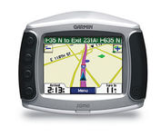
Designed specifically for motorcycles, the Garmin zumo 550 has a host of features that make it the easiest way to get GPS navigation on two wheels. Durable, waterproof, and built with fuel-resistant plastics, the zumo 550 can take a beating and hold up against even the most intense driving conditions. Right out of the box you’ll be able to chart out your ride with preloaded City Navigator NT street maps that are loaded with useful points of interest including restaurants, gas stations, and motels. Turn-by-turn voice directions keep you on track and with real-time traffic and weather updates you can avoid obstacles that might interfere with your otherwise, easy ride.Minimize


Magellan Maestro 3100
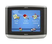

Magellan Maestro 3100 offers simple, sophisticated GPS navigation that's remarkably affordable. The most intuitive graphical 3.5" touch-screen interface available makes navigation easy. Enter virtually any destination and get turn-by-turn voice guidance to locations all over the contiguous United States. Smart touch-icons and Magellan's unique QuickSpell function enable error-free spelling, minimizing steps, so you get a customized route to your destination with just a few touches of the screen. Hundreds of thousands of preprogrammed points of interest make it easy to find restaurants, gas stations, ATM and more. Minimize


Nextar X3B
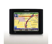

The Nextar GPS X3B mobile navigation system assures that your days of getting lost are over! Finding an address or any of 1.6 million points of interest such as the nearest gas station or restaurant is a snap anywhere in the U.S. or Canada. Just enter information in the X3B's 3.5 inch touch screen and let the voice prompt and detailed map guide you to the destination. With the latest TTS (Text to Speech) function, street names are clrearly pronounced in English. The X3B's built in MP3 player will entertain you with your favorite tunes while en route. Just copy your favorite play list onto an SD card and insert into the slot. The X3B moves easily from car to car using the convenient vent mount. A recharageable lithium ion battery assures that the unit stays active. Other features of the X3B include built-in maps of the 50 United States and Canada, 1GB built in Flash Memory.Minimize


Garmin eTrex Summit


The eTrex Summit comes on the heels of the extremely popular eTrex, which was designed for both marine and recreation use. This new all-in-one navigation device for the outdoor enthusiast is the first combination GPS, altimeter, and electronic compass. The electronic compass provides bearing information when you're standing still and the altimeter determines precise altitude, so you can tell how high you've climbed and your rate of ascent. Like its predecessor, the eTrex Summit boasts a powerful 12 parallel channel GPS receiver and comes packaged in a small, sleek case with operating buttons located on either side of the unit. The case is completely waterproof to withstand immersion in one meter of water for up to 30 minutes.Minimize