TomTom Navigator 3$150.00 to $160.00

Get moving with TomTom Navigator 3. The flexible and personal car navigation system works on your Pocket PC. TomTom Navigator 3 guides you effortlessly from door to door via the best route. Clear 3D colour maps and spoken instructions take the stress out of driving. Plan the best route when you have multiple stops: pick up colleagues on the way to a meeting or friends on the way to a restaurant. Route around areas you would like to avoid due to traffic jams or road works. The Major Roads of Europe feature makes planning and navigating international trips easier than ever. Plan the best route from Munich to Lyon, and TomTom will guide you there.Minimize
Manufacturer:TomTom Product MPN MPN | 1C90.080 | Key Features GPS Type | Handheld (Outdoor) | Form Factor | Handheld, Plug-in | Map capabilities | Internal, Download maps | Technical Features Audible Features | Voice Navigation Instructions | Trip calculator | Route Recalculation, Points-of-Interest (POI) | Included Software/Maps | Europe Maps | GPS System Accuisition Time - Cold | 51 sec | Accuisition Time - Initial Time | 37 sec | Accuisition Time - Hot | 3 sec | Waypoints | 1000 | PDA Features Compatible PDA OS | Pocket PC | Compatible Devices | Pocket PC Based PDA | Miscellaneous Family Line | Tomtom Navigator | UPC | 636926005876 |
Tags:tomtom, navigator, 3,
| GlobalSat BT-359$40.00 to $90.00
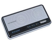
The GlobalSat BT-359 Bluetooth GPS receiver is our solution of the line Bluetooth GPS, which have both stylish and functional in true GlobalSat tradition. Taking its design criteria from the market leading BT-338 we have pushed the limits of GPS even further with greater sensitivity, more accuracy, and longer battery life than ever beforeMinimize
Manufacturer:GlobalSat Product MPN MPN | BT-359 | Key Features GPS Type | Handheld (Outdoor) | Form Factor | Wireless Receiver Module | Enhanced accuracy | WAAS enabled, EGNOS enabled | Receiver Type | 20 Channels | Other Features PC Interface | NMEA-0183, Bluetooth | Antenna | Built-in | GPS System Accuisition Time - Cold | 42 sec | Accuisition Time - Initial Time | 38 sec | Accuisition Time - Hot | 1 sec | Max. Horizontal accuracy | Battery | Battery Type and Quantity | Proprietary Lithium | Battery Life | 11 Hours | Dimensions Width | 3.23 in. | Depth | 0.53 in. | Height | 1.61 in. | Miscellaneous UPC | 4043619603046 |
Tags:globalsat, bt-359,
| Pharos Science PF080$89.00 to $241.00
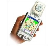
Pharos, the leader in advanced, affordable navigation solutions for handheld computing, has created the ultimate navigation tool for Windows Mobile-based Pocket PCs and mobile devices. Use Pharos Pocket GPS Navigator with CompactFlash to navigate door-to-door or point-to-point. Use it for hiking, walking tours or other outdoor activities. With audio voice prompts to guide you to your destination, the Pocket GPS Navigator is great for your car, too. In fact, the Pharos GPS Navigator performs just like more expensive, factory-installed, in-vehicle navigation systems, at a fraction of the cost yet, its easy to load into your Pocket PC and simple to use.Minimize
Manufacturer:Pharos Science Product MPN MPN | pf080 | Key Features GPS Type | Automobile | Form Factor | Handheld | Map capabilities | Download maps | Enhanced accuracy | WAAS enabled, EGNOS enabled | Receiver Type | 12 Channels | Technical Features Special Features | Compass | Audible Features | Voice Navigation Instructions | Trip calculator | Real-time Traffic Reports, Points-of-Interest (POI) | Other Features PC Interface | NMEA-0183 | Expansion Slot Type | Compact Flash (CF) | Antenna | Built-in | GPS System Accuisition Time - Cold | 60 sec | Accuisition Time - Initial Time | 40 sec | Accuisition Time - Hot | 5 sec | Update rate | 1 per second, continuous | Max. Horizontal accuracy | PDA Features | Plug-in Interface | Compact Flash (CF) | Dimensions Width | 1.93 in. | Depth | 0.63 in. | Height | 2.17 in. | Weight | 0.09 lb. | Miscellaneous UPC | 818948001030 |
Tags:pharos, science, pf080,
|

The GPS 76 is designed to provide precise GPS positioning using correction data obtained from the Wide Area Augmentation System (WAAS). This unit features a built-in quad helix antenna for superior reception and can provide position accuracy to less than three meters when receiving WAAS corrections.The GPS 76 provides 1 megabyte of internal user memory to be used for storing downloaded Points of Interest data. This 1 megabyte of storage area is preloaded from the factory with worldwide cities (populations greater than 200,000) and nautical navigation aids such as lights, buoys, sound signals and day beacons, and is perfect for downloading points of interest detail from GARMIN's line of MapSource CD-ROMs. The GPS 76 is also preloaded with tide data for the United States.Minimize

This preloaded, offshore chartplotter combines the power of networking with brilliant color and slim-line design. The GPSMAP 4212 has preloaded BlueChart® g2 maps of the U.S. coast and displays them on a whopping 12.1” XGA display with crisp, video-quality resolution. By connecting to the Garmin Marine Network, you can add sonar, radar and weather. For even more enhanced features, you can add the optional Bluechart g2 Vision card.Minimize

The GPS 72 is a low-cost solution for land or marine navigation designed to provide precise GPS positioning using correction data obtained from the Wide Area Augmentation System (WAAS). The GPS 72 can provide position accuracy to less than three meters when receiving WAAS corrections. This rugged, waterproof, unsinkable GPS receiver offers a large, 4-level grayscale screen. It's designed as the next generation in basic, entry-level GARMIN GPS.Minimize

StreetPilot c530 comes ready to go right out of the box with preloaded City Navigator® NT street maps and a hefty points of interest (POIs) database, including motels, restaurants, fuel, ATMs and more. Simply touch the super-bright sunlight-readable color screen to enter a destination, and the c530 takes you there with 2D or 3D maps and turn-by-turn voice directions. In addition, the c530 accepts custom points of interest (POIs) such as school zones and safety cameras and lets you set proximity alerts to warn you of upcoming POIs.Minimize