TomTom Navigator 3$150.00 to $160.00

Get moving with TomTom Navigator 3. The flexible and personal car navigation system works on your Pocket PC. TomTom Navigator 3 guides you effortlessly from door to door via the best route. Clear 3D colour maps and spoken instructions take the stress out of driving. Plan the best route when you have multiple stops: pick up colleagues on the way to a meeting or friends on the way to a restaurant. Route around areas you would like to avoid due to traffic jams or road works. The Major Roads of Europe feature makes planning and navigating international trips easier than ever. Plan the best route from Munich to Lyon, and TomTom will guide you there.Minimize
Manufacturer:TomTom Product MPN MPN | 1C90.080 | Key Features GPS Type | Handheld (Outdoor) | Form Factor | Handheld, Plug-in | Map capabilities | Internal, Download maps | Technical Features Audible Features | Voice Navigation Instructions | Trip calculator | Route Recalculation, Points-of-Interest (POI) | Included Software/Maps | Europe Maps | GPS System Accuisition Time - Cold | 51 sec | Accuisition Time - Initial Time | 37 sec | Accuisition Time - Hot | 3 sec | Waypoints | 1000 | PDA Features Compatible PDA OS | Pocket PC | Compatible Devices | Pocket PC Based PDA | Miscellaneous Family Line | Tomtom Navigator | UPC | 636926005876 |
Tags:tomtom, navigator, 3,
| Garmin GPS 18$48.00 to $169.00
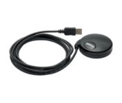
Turn your laptop PC into a powerful street navigator with the GPS 18 a GPS sensor bundled with nRoute and City Select software that automatically guides you with turn-by-turn directions and voice prompts to get you safely to your destination.
Manufacturer:Garmin Product MPN MPN | 010-00321-54 | Key Features GPS Type | Handheld (Outdoor) | Form Factor | Handheld, Plug-in | Map capabilities | Download maps | Enhanced accuracy | WAAS enabled | Receiver Type | 12 Channels | Technical Features Audible Features | Voice Navigation Instructions | Trip calculator | Points-of-Interest (POI) | Included Software/Maps | North America Maps, Europe Maps, South America Maps | Other Features PC Interface | USB 2.0, USB | GPS System Accuisition Time - Cold | 45 sec | Accuisition Time - Initial Time | 15 sec | Update rate | 1 per second, continuous | Max. Horizontal accuracy | | Enhanced position accuracy | | Differential standards | DGPS Ready | Warranty Warranty | 1 Year | Dimensions Width | 2.4 in. | Depth | 2.4 in. | Height | 0.77 in. | Weight | 0.22 lb. | Miscellaneous Family Line | Garmin GPS | UPC | 753759042714 |
Tags:garmin, gps, 18,
| Garmin Rino 120$167.00 to $628.00
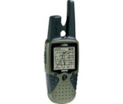
The Rino 120 is state-of-the-art GPS navigation and two-way communications combined, with enough memory to download detailed mapping for driving, hiking, hunting, fishing--or just about anything else you can dream up.
Manufacturer:Garmin Product MPN MPN | RINO120 | Key Features GPS Type | Handheld (Outdoor) | Form Factor | Handheld | Map capabilities | Internal, Download maps | Enhanced accuracy | WAAS enabled | Input Method | Thumb Stick | Receiver Type | 12 Channels | Screen Size | 2 in. | Display Display Size | 1.4 in. x 1.4 in. | Display Type | LCD Display | Resolutions | 160 X 160 | Technical Features Marine Features | Fishing Calcluator | Special Features | Waypoint Icons | Audible Features | Proximity Alarm | Trip calculator | Maximum speed, Current speed, Trip Timers, Time of sunrise/sunset, Track Log, Points-of-Interest (POI) | Included Software/Maps | Marine Cartography, North America Maps, South America Maps | Grids | Lat/Lon, MGRS, UTM, Loran TD position format, Maidenhead | Other Features PC Interface | Serial RS-232, NMEA-0183 | Environmental Protection | IPX7 Waterproof Standard | Antenna | Quadrifilar Helix | GPS System Accuisition Time - Cold | 45 sec | Accuisition Time - Initial Time | 15 sec | Update rate | 1 per second, continuous | Max. Horizontal accuracy | | Enhanced position accuracy | | Differential standards | DGPS Ready | Number of routes | 20 | Waypoints | 500 | Battery Battery Type and Quantity | 3 x AA Batteries | Battery Life | 28 Hours | Warranty Warranty | 1 Year | Dimensions Width | 2.3 in. | Depth | 1.6 in. | Height | 4.5 in. | Weight | 0.48 lb. | Miscellaneous Family Line | Garmin Rino | UPC | 689076630887 |
Tags:garmin, rino, 120,
|
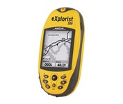
For serious outdoor use, the eXplorist series handheld GPS navigation systems are built to cover all requirements. With their tough, impact-resistant, waterproof exterior and their proven Magellan technology inside that packs powerful functionality into an easy-to-use operating system, your outdoor needs will be covered.Minimize

The GP-7000F/NT is a GPS/WAAS plotter designed for a variety of vessels desiring video plotting and echo sounding capabilities. With the GP-7000 series, you can see the highly accurate position of your boat on the chart. The GP-7000 series has four display modes: Course Plot, Nav Data, Steering, and Highway modes. The course plot mode is useful for obtaining general information about surrounding sea areas. The Nav data mode clearly shows important navigational information with large text, which is easy to see even from a distance. The steering mode and highway mode assist the operator in following a predetermined route.Minimize

One of the first things a boater will notice about the Chart Master V6 series is their vertically oriented high-definition (234x320 pixel) six-inch super-bright color LCD displays. They provide clear visibility even in full sunlight, and the Chart Master V6I, with it's built-in GPS antenna is a great choice for boats with open cockpits, center consoles and flying bridges and can serve well as a back-up unitMinimize
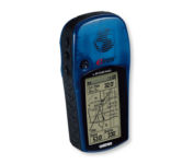
With the eTrex Legend, GARMIN has loaded a full basemap of North and South America into one small unit. The Legend is also designed to provide precise GPS positioning using correction data obtained from the Wide Area Augmentation System (WAAS). This product will provide position accuracy to less than three meters when receiving WAAS corrections.Minimize