Products reviews

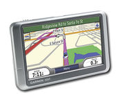
Garmin nuvi 200W

$150.00 to $350.00


Wide and way cool, nüvi 200W shows you the way with detailed maps on a bright widescreen display and clear, voice-prompted directions. This stylish navigator and travel companion comes with preloaded maps for the lower 48 states, Hawaii and Puerto Rico or regional coverage in other areas. Like the rest of the nüvi 200-series, nüvi 200W is affordably priced and simple to use.Minimize

Manufacturer:Garmin Product MPNKey FeaturesDisplayTechnical FeaturesOther FeaturesGPS SystemBatteryDimensionsMiscellaneous
MPN010-N0656-1
GPS Type   Automobile
Form FactorFixed
Map capabilities   Internal, Map cartridges / Data cards
Enhanced accuracyWAAS enabled, EGNOS enabled
Input Method   Touch Screen
Receiver Type12 Channels
Screen Size4.4 in.
Display Size3.81 in. x 2.25 in.
Display Type65k Colors Display
Resolutions480 x 272
Special Features   Waypoint Icons, JPEG Image Viewer, Converter, Calculator, 3D Map View
Audible Features   Voice Navigation Instructions
Trip calculator   Shortest time, Shortest distance, Maximum speed, Odometer, Current speed, Route Recalculation, Trip Timers, Avoid toll roads, Detour Feature, Points-of-Interest (POI)
Included Software/Maps   Europe Maps, Germany Maps
PC InterfaceUSB
Expansion Slot TypeSD (Secure Digital) Card Slot
AntennaBuilt-in
Waypoints   500
Battery Type and QuantityRechargeable Li-Ion Battery
Battery Life5 Hours
Width4.8 in.
Depth0.8 in.
Height2.9 in.
Weight0.38 lb.
Family LineGarmin nuvi
UPC753759074524


Tags:

garmin, nuvi, 200w,

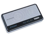
GlobalSat BT-359

$40.00 to $90.00


The GlobalSat BT-359 Bluetooth GPS receiver is our solution of the line Bluetooth GPS, which have both stylish and functional in true GlobalSat tradition. Taking its design criteria from the market leading BT-338 we have pushed the limits of GPS even further with greater sensitivity, more accuracy, and longer battery life than ever beforeMinimize

Manufacturer:GlobalSat Product MPNKey FeaturesOther FeaturesGPS SystemDimensionsMiscellaneous
MPNBT-359
GPS Type   Handheld (Outdoor)
Form FactorWireless Receiver Module
Enhanced accuracyWAAS enabled, EGNOS enabled
Receiver Type20 Channels
PC InterfaceNMEA-0183, Bluetooth
AntennaBuilt-in
Accuisition Time - Cold42 sec
Accuisition Time - Initial Time38 sec
Accuisition Time - Hot1 sec
Max. Horizontal accuracy   Battery
Battery Type and QuantityProprietary Lithium
Battery Life11 Hours
Width3.23 in.
Depth0.53 in.
Height1.61 in.
UPC4043619603046


Tags:

globalsat, bt-359,

Garmin GPSMAP 4212

$2,200.00 to $3,000.00


This preloaded, offshore chartplotter combines the power of networking with brilliant color and slim-line design. The GPSMAP 4212 has preloaded BlueChart® g2 maps of the U.S. coast and displays them on a whopping 12.1” XGA display with crisp, video-quality resolution. By connecting to the Garmin Marine Network, you can add sonar, radar and weather. For even more enhanced features, you can add the optional Bluechart g2 Vision card.Minimize

Manufacturer:Garmin Product MPNKey FeaturesDisplayTechnical FeaturesOther FeaturesGPS SystemDimensionsMiscellaneous
MPN010-00592-01
GPS Type   Marine
Form FactorFixed
Map capabilities   Internal
Enhanced accuracyWAAS enabled
Input Method   Keypad
Receiver Type12 Channels
Screen Size12.1 in.
Display Size9.7 in. x 7.3 in.
Resolutions640 X 480
Audible Features   Proximity Alarm, Anchor Alarm, Arrival Alarm, Off-Course Alarm, Clock Alarm, Accuracy Alarm, Low Battary/Voltage Alarm
Trip calculator   Track Log, Points-of-Interest (POI)
Included Software/Maps   Marine Cartography
Expansion Slot TypeSD (Secure Digital) Card Slot
Number of routes20
Waypoints   1500
Width14.8 in.
Depth4.6 in.
Height9.5 in.
Weight10 lb.
Family LineGarmin GPSMAP
UPC753759066062


Tags:

garmin, gpsmap, 4212,


Lowrance iFINDER Hunt C

The handheld mapping GPS designed by hunters for hunters lets you follow the big game in color with 16-channel GPS precision. The iFINDER® Hunt C with color display offers everything you'd expect in a versatile, precision mapping GPS unit made for the field, including hunting-specific icons, unique "Scout Mode", electronic compass, barometric altimeter, built-in microphone, and more.Minimize


Garmin GPS 76


The GPS 76 is designed to provide precise GPS positioning using correction data obtained from the Wide Area Augmentation System (WAAS). This unit features a built-in quad helix antenna for superior reception and can provide position accuracy to less than three meters when receiving WAAS corrections.The GPS 76 provides 1 megabyte of internal user memory to be used for storing downloaded Points of Interest data. This 1 megabyte of storage area is preloaded from the factory with worldwide cities (populations greater than 200,000) and nautical navigation aids such as lights, buoys, sound signals and day beacons, and is perfect for downloading points of interest detail from GARMIN's line of MapSource CD-ROMs. The GPS 76 is also preloaded with tide data for the United States.Minimize


Garmin StreetPilot c580
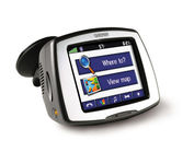

Receive door-to-door directions while staying on top of weather, traffic and localized information with the StreetPilot c580. Similar to the c550, StreetPilot c580 comes with hands-free calling, preloaded maps and an MP3 player, then takes it up a notch by adding dynamic content from MSN® Direct.


Magellan eXplorist 200
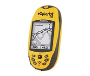

For serious outdoor use, the eXplorist series handheld GPS navigation systems are built to cover all requirements. With their tough, impact-resistant, waterproof exterior and their proven Magellan technology inside that packs powerful functionality into an easy-to-use operating system, your outdoor needs will be covered.Minimize