Lowrance iFINDER Hunt C$445.00 to $590.00

The handheld mapping GPS designed by hunters for hunters lets you follow the big game in color with 16-channel GPS precision. The iFINDER® Hunt C with color display offers everything you'd expect in a versatile, precision mapping GPS unit made for the field, including hunting-specific icons, unique "Scout Mode", electronic compass, barometric altimeter, built-in microphone, and more.Minimize
Manufacturer:Lowrance Product MPN MPN | 112-73 | Key Features GPS Type | Handheld (Outdoor) | Form Factor | Handheld | Map capabilities | Internal, Map cartridges / Data cards | Enhanced accuracy | WAAS enabled, EGNOS enabled | Input Method | Keypad | Receiver Type | 16 Channels | Display Display Size | 2.62 in. | Display Type | 256 Color LCD TFT Display | Resolutions | 240 X 160 | Technical Features Marine Features | MOB (Man Over Board) | Special Features | Waypoint Icons, Compass, Built-In Barometer, Built-In Altimeter, MP3 Player, Voice Recorder | Included Software/Maps | USA Maps, Hawaii | Grids | Irish, WGS 84 | Other Features PC Interface | NMEA-0183 | Environmental Protection | IPX7 Waterproof Standard | Expansion Slot Type | SD (Secure Digital) Card Slot, MultiMediaCard (MMC) slot | Antenna | External Antenna Hookup | GPS System Update rate | 1 per second, continuous | Enhanced position accuracy | | Number of routes | 100 | Waypoints | 2000 | Battery Battery Type and Quantity | 2 x AA Batteries | Battery Life | 16 Hours | Warranty Warranty | 1 Year | Dimensions Width | 2.5 in. | Depth | 1.2 in. | Height | 5.6 in. | Weight | 0.54 lb. | Miscellaneous Family Line | Lowrance iFINDER | UPC | 042194524757 |
Tags:lowrance, ifinder, hunt, c,
| Navman NavPix N40i$80.00 to $230.00
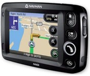
The N40i includes an integrated digital camera for taking NavPix to create an unmistakeable reminder of your chosen destination. So you can find your way there - no matter how far away it is – whenever you want.
Manufacturer:Navman Product MPN MPN | N40i | Key Features GPS Type | Automobile | Input Method | Touch Screen | Display Display Size | 3.5 in. | Display Type | LCD Display | Technical Features Audible Features | Voice Navigation Instructions | Included Software/Maps | USA Maps, Europe Maps, Australia Maps, Ireland | Other Features PC Interface | USB 1.1 | Built in memory | 64 MB | GPS System Update rate | 1 per second, continuous | Battery Battery Type and Quantity | Rechargeable Li-Ion Battery | Battery Life | 5 Hours | Dimensions Width | 4.65 in. | Depth | 0.89 in. | Height | 3.19 in. | Weight | 0.44 lb. | Miscellaneous UPC | 817186001376 |
Tags:navman, navpix, n40i,
| Dual Electronics XNAV3550$219.00 to $228.00

The Dual XNA3550 features an easy to use touch screen graphic interface with MP3 playback capability. Turn-by-turn instructions with voice guidance. Visual left/right LED indicators. 3D Map view. Level selectable map view. Start route guidance search by:- Address/intersection- Points of interest- Address book- Recent destination. GPS status indicator.Minimize
Manufacturer:Dual Electronics Product MPN MPN | XNAV3550 | Key Features GPS Type | Automobile | Form Factor | Fixed | Map capabilities | Internal | Input Method | Touch Screen | Receiver Type | 12 Channels | Display Display Size | 3.5 in. | Display Type | 16.7M Colors LCD TFT Display | Resolutions | 320 X 240 | Technical Features Special Features | Address Book, MP3 Player, 3D Map View | Trip calculator | Route Recalculation, Points-of-Interest (POI) | Included Software/Maps | USA Maps | Other Features Built in memory | 64 MB | Expansion Slot Type | SD (Secure Digital) Card Slot | Antenna | Built-in | PDA Features Plug-in Interface | Secure Digital (SD) | Compatible PDA OS | Windows CE | Battery Battery Type and Quantity | Rechargeable Li-Ion Battery | Battery Life | 2 Hours | Dimensions Width | 5.25 in. | Depth | 1.25 in. | Height | 3.13 in. | Weight | 2.1 lb. | Miscellaneous UPC | 827204101636 |
Tags:dual, electronics, xnav3550,
|

The Rino 110 is a GPS-enabled handheld that integrates radio functionality to provide two-way communications. It's waterproof, can send communications up to five miles (using GMRS channels), and can "beam" your exact location to another Rino user within a two-mile range (on the FRS spectrum) using "Position Reporting". And because the Rino 110 has standard FRS capabilities, you can talk to friends or family who own conventional FRS radios.The Rino 110 has a built-in city point data base, with 1 MB of internal memory for additional points-of-interest data that can be downloaded from a MapSource Points of Interest CD-ROM.Minimize

Rugged, lightweight Edge attaches easily to the stem or handlebars of your bike with the included bike mount. Just turn it on, acquire GPS satellites and go. Edge 305 automatically measures your speed, distance, time, calories burned, altitude, climb and descent, and also records the route you have taken for review. For extra-precise climb and descent data, Edge 305 also incorporates a barometric altimeter to pinpoint changes in elevation.Minimize
The Dual XNA3550 features an easy to use touch screen graphic interface with MP3 playback capability. Turn-by-turn instructions with voice guidance. Visual left/right LED indicators. 3D Map view. Level selectable map view. Start route guidance search by:- Address/intersection- Points of interest- Address book- Recent destination. GPS status indicator.Minimize
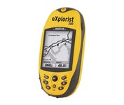
For serious outdoor use, the eXplorist series handheld GPS navigation systems are built to cover all requirements. With their tough, impact-resistant, waterproof exterior and their proven Magellan technology inside that packs powerful functionality into an easy-to-use operating system, your outdoor needs will be covered.Minimize