Products reviews

Interphase Corporation Chart Master V6i

$531.00 to $573.00


One of the first things a boater will notice about the Chart Master V6 series is their vertically oriented high-definition (234x320 pixel) six-inch super-bright color LCD displays. They provide clear visibility even in full sunlight, and the Chart Master V6I, with it's built-in GPS antenna is a great choice for boats with open cockpits, center consoles and flying bridges and can serve well as a back-up unitMinimize

Manufacturer:Interphase Corporation Product MPNKey FeaturesDisplayTechnical FeaturesOther FeaturesGPS SystemWarrantyDimensionsMiscellaneous
MPNU1CHRTV6I
GPS Type   Marine
Form FactorFixed
Map capabilities   Internal, Map cartridges / Data cards
Enhanced accuracyWAAS enabled
Input Method   Keypad, Thumb Stick
Receiver Type12 Channels
Display Size5.7 in.
Display Type256 Color LCD TFT Display
Resolutions234 X 320
Marine FeaturesTide Prediction, Depth Display, Chart Plotter, Sonar / Sounder, MOB (Man Over Board)
Special Features   Waypoint Icons, Compass
Audible Features   Shallow/Deep Alarm
Included Software/Maps   Marine Cartography
Grids   Lat/Lon
PC InterfaceUSB, NMEA-0183, NMEA-0180
AntennaBuilt-in
Accuisition Time - Cold45 sec
Accuisition Time - Hot8 sec
Update rate1 per second, continuous
Enhanced position accuracy Number of routes25
Waypoints   500
Warranty5 Years
Width3.38 in.
Depth2 in.
Height4.5 in.
Weight2 lb.
UPC027037002692


Tags:

interphase, corporation, chart, master, v6i,

DeLorme Earthmate

$142.00 to $550.00


Never Get Lost Again When was the last time you wasted valuable travel time because you took a wrong turn in an unfamiliar location? Now there's an affordable and reliable solution - the new Earthmate GPS receiver. The small and flexible Earthmate GPS receiver is a high-performance, easy-to-use link to the satellite navigation technology of the Global Positioning System (GPS). Accessing these satellites is available for no additional charge. Earthmate, connected to a USB laptop PC, shows your real-time position on detailed Street Atlas USA maps anywhere in the U.S. (software included). You will always know where you are and where you need to go.Minimize

Manufacturer:DeLorme Product MPNKey FeaturesTechnical FeaturesOther FeaturesGPS SystemDimensions
MPNAE-006761-201
GPS Type   Automobile
Form FactorWireless Receiver Module
Map capabilities   Internal
Enhanced accuracyWAAS enabled
Receiver Type12 Channels
Included Software/Maps   USA Maps
PC InterfaceUSB
Accuisition Time - Cold45 sec
Max. Horizontal accuracy   Enhanced position accuracyPDA Features
Compatible PDA OSWindows XP, Windows 2000, Windows ME, Windows 98SE
Compatible DevicesNotebook
Width1.88 in.
Height2.09 in.


Tags:

delorme, earthmate,

Garmin StreetPilot c550

$199.00 to $400.00


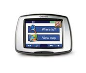
From Garmin, the leader in portable GPS solutions, the StreetPilot c550 is easy to use, and rich with features. The StreetPilot c550 comes preloaded with City Navigator NT street maps and includes a large database of points of interest including motels, restaurants, gas stations, and grocery stores. The simple touch screen interface gives you excellent control over menus and settings, and with Bluetooth support, you can even use the c550 for hands-free calling using the built-in speaker and microphone.Minimize

Manufacturer:Garmin Product MPNKey FeaturesDisplayTechnical FeaturesOther FeaturesGPS SystemBatteryWarrantyDimensionsMiscellaneous
MPN010-00522-02
GPS Type   Automobile
Form FactorFixed
Map capabilities   Internal, Map cartridges / Data cards
Enhanced accuracyWAAS enabled
Input Method   Touch Screen
Screen Size3.5 in.
Display Size2.8 in. x 2.1 in.
Display TypeLCD TFT Display
Resolutions320 X 240
Special Features   Waypoint Icons, MP3 Player, 3D Map View
Audible Features   Voice Navigation Instructions
Trip calculator   Maximum speed, Odometer, Route Recalculation, Trip Timers, Real-time Traffic Reports, Detour Feature, Points-of-Interest (POI)
Included Software/Maps   North America Maps, Europe Maps
PC InterfaceUSB 2.0, Bluetooth
Expansion Slot TypeSD (Secure Digital) Card Slot
AntennaBuilt-in, External Antenna Hookup
Waypoints   500
Battery Life8 Hours
Warranty1 Year
Width4.4 in.
Depth2.2 in.
Height3.2 in.
Weight0.59 lb.
Family LineGarmin StreetPilot
UPC753759054489


Tags:

garmin, streetpilot, c550,


Garmin nüvi 350


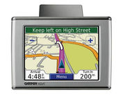
Sleek and portable, the Garmin nuvi 350 comes preloaded with City Navigator NT street maps that highlight countless points of interest including hotels, restaurants, gas stations, ATMs and much more. A simple touch-screen interface allows you to quickly pull up 2-D or 3-D maps, and with turn-by-turn voice directions, you’ll never have to take your eyes off the road to get your bearings. The nuvi 350 also includes MP3 playback, a JPEG picture viewer, currency converters, and a host of other travel handy applications.Minimize


Lowrance iFINDER GO2
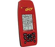

Just grab this bright yellow handheld iFINDER Go 64MB GPS and go, go, go. It's easy to use, waterproof, has a 2.2 diagonal Film SuperTwist display with backlighting and a built-in 64MB background map with coverage of the continental U.S. and Hawaii. The GPS also includes up to 1,000 waypoints, 1,000 event markers and 100 routes; up to 100 retraceable plot trails and up to 10,000 points in any trail; 30+ map zoom ranges and 42 graphic icons to mark spots.Minimize


Garmin Rino 130
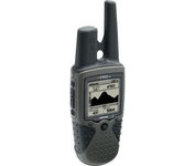

The Rino 130 is the most feature-rich unit in the Rino family with a built-in electronic compass barometric sensor weather receiver for seven NOAA weather channels and 24 MBs of internal memory This handheld radio has a built-in electronic compass to give a heading while the user is standing still and a barometric altimeter to provide extremely accurate elevation and pressure information which will assist users in identifying weather data The Rino 130 provides two-way radio communication with a transmission range of up to two miles using FRS channels and up to five miles with GMRS The integration of two-way radio and GPS enables users to transmit their position with a simple button press allowing others to navigate to their position The Rino 130 also has a polling feature which allows a user to manually request GPS location information from other Rino unitsMinimize


Garmin Rino 110


The Rino 110 is a GPS-enabled handheld that integrates radio functionality to provide two-way communications. It's waterproof, can send communications up to five miles (using GMRS channels), and can "beam" your exact location to another Rino user within a two-mile range (on the FRS spectrum) using "Position Reporting". And because the Rino 110 has standard FRS capabilities, you can talk to friends or family who own conventional FRS radios.The Rino 110 has a built-in city point data base, with 1 MB of internal memory for additional points-of-interest data that can be downloaded from a MapSource Points of Interest CD-ROM.Minimize