Navman NavPix N40i$80.00 to $230.00

The N40i includes an integrated digital camera for taking NavPix to create an unmistakeable reminder of your chosen destination. So you can find your way there - no matter how far away it is – whenever you want.
Manufacturer:Navman Product MPN MPN | N40i | Key Features GPS Type | Automobile | Input Method | Touch Screen | Display Display Size | 3.5 in. | Display Type | LCD Display | Technical Features Audible Features | Voice Navigation Instructions | Included Software/Maps | USA Maps, Europe Maps, Australia Maps, Ireland | Other Features PC Interface | USB 1.1 | Built in memory | 64 MB | GPS System Update rate | 1 per second, continuous | Battery Battery Type and Quantity | Rechargeable Li-Ion Battery | Battery Life | 5 Hours | Dimensions Width | 4.65 in. | Depth | 0.89 in. | Height | 3.19 in. | Weight | 0.44 lb. | Miscellaneous UPC | 817186001376 |
Tags:navman, navpix, n40i,
| DeLorme Earthmate$142.00 to $550.00

Never Get Lost Again When was the last time you wasted valuable travel time because you took a wrong turn in an unfamiliar location? Now there's an affordable and reliable solution - the new Earthmate GPS receiver. The small and flexible Earthmate GPS receiver is a high-performance, easy-to-use link to the satellite navigation technology of the Global Positioning System (GPS). Accessing these satellites is available for no additional charge. Earthmate, connected to a USB laptop PC, shows your real-time position on detailed Street Atlas USA maps anywhere in the U.S. (software included). You will always know where you are and where you need to go.Minimize
Manufacturer:DeLorme Product MPN MPN | AE-006761-201 | Key Features GPS Type | Automobile | Form Factor | Wireless Receiver Module | Map capabilities | Internal | Enhanced accuracy | WAAS enabled | Receiver Type | 12 Channels | Technical Features Included Software/Maps | USA Maps | Other Features PC Interface | USB | GPS System Accuisition Time - Cold | 45 sec | Max. Horizontal accuracy | | Enhanced position accuracy | PDA Features | Compatible PDA OS | Windows XP, Windows 2000, Windows ME, Windows 98SE | Compatible Devices | Notebook | Dimensions Width | 1.88 in. | Height | 2.09 in. |
Tags:delorme, earthmate,
| Lowrance M68C$394.00 to $526.00

Combining the 256-color technology of the sonar industry and the superior precision of Lowrance GPS units, the M-68c sonar/map gives you all the capabilities of the extreme high-end combo units in a smaller, more affordable package. Features a full 12-parallel channel GPS and WAAS receiver and 40 map ranges from .02 to 4,000 miles with easy zoom. The high-bright 3.5" diagonal TFT active matrix transflective display delivers a wide viewing angle and superb readability in direct sunlight. And, it includes an advanced LED screen and keypad backlighting for night and low-light operation.Minimize
Manufacturer:Lowrance Product MPN MPN | 3842201200 | Key Features GPS Type | Marine | Form Factor | Fixed | Map capabilities | Internal | Enhanced accuracy | WAAS enabled | Input Method | Keypad | Receiver Type | 12 Channels | Display Display Size | 3.5 in. | Display Type | 256 Color LCD TFT Display | Resolutions | 320 X 240 | Technical Features Marine Features | Fish Finder, Split Screen, MOB (Man Over Board) | Special Features | Waypoint Icons | Audible Features | Proximity Alarm, Anchor Alarm, Arrival Alarm, Off-Course Alarm, Fish Alarm, Shallow/Deep Alarm | Trip calculator | Trip Timers, Time of sunrise/sunset | Other Features Antenna | Built-in | GPS System Number of routes | 100 | Waypoints | 1000 | Warranty Warranty | 1 Year | Dimensions Width | 4.23 in. | Depth | 3.26 in. | Height | 6.26 in. |
Tags:lowrance, m68c,
|

Accidents happen every day in the outdoors, whether you fall out of a tree stand, break a leg during a hike, or roll over on an ATV. In the outdoors, an every day accident instantly can become a life threatening situation, and rescues may take days or weeks if you’re not prepared.

Packed with features and available in a variety of hip colors, the Garmin nuvi 250 is affordably priced and easy to use. The nuvi 250 comes preloaded with City Navigator map data giving you quick, turn-by-turn directions to anywhere in the continental United States. Pull up colorful, 2-D or 3-D maps on the sunlight-readable screen and voice directions will guide you safely and quickly to your selected destination. You can also set custom points of interest on the nuvi 250 such as your favorite restaurants or coffee shops, and with proximity alerts you’re always aware of where you’re going, and where you’ve been.Minimize

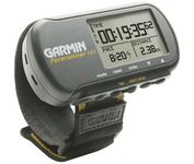
The Forerunner 101 offers athletes and recreational walkers and runners an entry-level personal training device with GPS. It has the same features as the Forerunner 201, but operates on two AAA batteries. The Forerunner 101 stores lap histories for up to two years to provide an archive of workout performance over time. Users can retrieve lap data for previous workouts by date, week, month, or over a specific time interval. For business travelers who want to train on the road, the Forerunner 101 also doubles as a navigator. Users can mark their hotel as a specific location, see their current position on the plotter display, and follow an electronic breadcrumb trail back to their starting point.Minimize

The AmbiCom GPS Navigation Receiver CompactFlash Card is the Global Positioning System Receiver for your mobile device and the perfect accessory to your Pocket PC device. The GPS Navigation Receiver comes with a full feature 30-day trial version software that is loaded with fantastic features such as dynamic voice navigation, off-route warning, and detailed street maps. Now you can turn your Pocket PC into a true GPS navigation system and never worry about getting lost!Minimize


