Kenwood KNA-G510$250.00 to $799.00
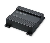
You'll give your Kenwood in-dash mobile video system a potent extra dimension when you connect the KNA-G510 navigation system. You'll drive with confidence as it guides you to your destination efficiently and accurately. The system can even keep you up to date on what's happening with traffic flow along your programmed route.Minimize
Manufacturer:Kenwood Product MPN MPN | KNA-G510 | Key Features GPS Type | Automobile | Form Factor | Fixed | Map capabilities | Internal | Enhanced accuracy | WAAS enabled | Input Method | Touch Screen | Receiver Type | 12 Channels | Technical Features Audible Features | Voice Navigation Instructions | Trip calculator | Trip Timers, Points-of-Interest (POI) | Included Software/Maps | North America Maps | Other Features Expansion Slot Type | SD (Secure Digital) Card Slot | Antenna | Built-in | Dimensions Width | 4.5 in. | Depth | 1.5 in. | Height | 4 in. |
Tags:kenwood, kna-g510,
| Lowrance iFINDER Hunt C$445.00 to $590.00

The handheld mapping GPS designed by hunters for hunters lets you follow the big game in color with 16-channel GPS precision. The iFINDER® Hunt C with color display offers everything you'd expect in a versatile, precision mapping GPS unit made for the field, including hunting-specific icons, unique "Scout Mode", electronic compass, barometric altimeter, built-in microphone, and more.Minimize
Manufacturer:Lowrance Product MPN MPN | 112-73 | Key Features GPS Type | Handheld (Outdoor) | Form Factor | Handheld | Map capabilities | Internal, Map cartridges / Data cards | Enhanced accuracy | WAAS enabled, EGNOS enabled | Input Method | Keypad | Receiver Type | 16 Channels | Display Display Size | 2.62 in. | Display Type | 256 Color LCD TFT Display | Resolutions | 240 X 160 | Technical Features Marine Features | MOB (Man Over Board) | Special Features | Waypoint Icons, Compass, Built-In Barometer, Built-In Altimeter, MP3 Player, Voice Recorder | Included Software/Maps | USA Maps, Hawaii | Grids | Irish, WGS 84 | Other Features PC Interface | NMEA-0183 | Environmental Protection | IPX7 Waterproof Standard | Expansion Slot Type | SD (Secure Digital) Card Slot, MultiMediaCard (MMC) slot | Antenna | External Antenna Hookup | GPS System Update rate | 1 per second, continuous | Enhanced position accuracy | | Number of routes | 100 | Waypoints | 2000 | Battery Battery Type and Quantity | 2 x AA Batteries | Battery Life | 16 Hours | Warranty Warranty | 1 Year | Dimensions Width | 2.5 in. | Depth | 1.2 in. | Height | 5.6 in. | Weight | 0.54 lb. | Miscellaneous Family Line | Lowrance iFINDER | UPC | 042194524757 |
Tags:lowrance, ifinder, hunt, c,
| TomTom Navigator 3$150.00 to $160.00

Get moving with TomTom Navigator 3. The flexible and personal car navigation system works on your Pocket PC. TomTom Navigator 3 guides you effortlessly from door to door via the best route. Clear 3D colour maps and spoken instructions take the stress out of driving. Plan the best route when you have multiple stops: pick up colleagues on the way to a meeting or friends on the way to a restaurant. Route around areas you would like to avoid due to traffic jams or road works. The Major Roads of Europe feature makes planning and navigating international trips easier than ever. Plan the best route from Munich to Lyon, and TomTom will guide you there.Minimize
Manufacturer:TomTom Product MPN MPN | 1C90.080 | Key Features GPS Type | Handheld (Outdoor) | Form Factor | Handheld, Plug-in | Map capabilities | Internal, Download maps | Technical Features Audible Features | Voice Navigation Instructions | Trip calculator | Route Recalculation, Points-of-Interest (POI) | Included Software/Maps | Europe Maps | GPS System Accuisition Time - Cold | 51 sec | Accuisition Time - Initial Time | 37 sec | Accuisition Time - Hot | 3 sec | Waypoints | 1000 | PDA Features Compatible PDA OS | Pocket PC | Compatible Devices | Pocket PC Based PDA | Miscellaneous Family Line | Tomtom Navigator | UPC | 636926005876 |
Tags:tomtom, navigator, 3,
|

Rugged, lightweight Edge attaches easily to the stem or handlebars of your bike with the included bike mount. Just turn it on, acquire GPS satellites and go. Edge 305 automatically measures your speed, distance, time, calories burned, altitude, climb and descent, and also records the route you have taken for review. For extra-precise climb and descent data, Edge 305 also incorporates a barometric altimeter to pinpoint changes in elevation.Minimize

The GP-7000F/NT is a GPS/WAAS plotter designed for a variety of vessels desiring video plotting and echo sounding capabilities. With the GP-7000 series, you can see the highly accurate position of your boat on the chart. The GP-7000 series has four display modes: Course Plot, Nav Data, Steering, and Highway modes. The course plot mode is useful for obtaining general information about surrounding sea areas. The Nav data mode clearly shows important navigational information with large text, which is easy to see even from a distance. The steering mode and highway mode assist the operator in following a predetermined route.Minimize
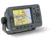
Plug into the power of the Garmin Marine network with the Garmin 3200 series. Rugged, waterproof, and easy to install, these chartplotters come preloaded with Garmin's detail-rich marine cartography utilizing BlueChart® g2 technology.

The GPS 72 is a low-cost solution for land or marine navigation designed to provide precise GPS positioning using correction data obtained from the Wide Area Augmentation System (WAAS). The GPS 72 can provide position accuracy to less than three meters when receiving WAAS corrections. This rugged, waterproof, unsinkable GPS receiver offers a large, 4-level grayscale screen. It's designed as the next generation in basic, entry-level GARMIN GPS.Minimize