Products reviews

Garmin GPSMAP 4212

$2,200.00 to $3,000.00


This preloaded, offshore chartplotter combines the power of networking with brilliant color and slim-line design. The GPSMAP 4212 has preloaded BlueChart® g2 maps of the U.S. coast and displays them on a whopping 12.1” XGA display with crisp, video-quality resolution. By connecting to the Garmin Marine Network, you can add sonar, radar and weather. For even more enhanced features, you can add the optional Bluechart g2 Vision card.Minimize

Manufacturer:Garmin Product MPNKey FeaturesDisplayTechnical FeaturesOther FeaturesGPS SystemDimensionsMiscellaneous
MPN010-00592-01
GPS Type   Marine
Form FactorFixed
Map capabilities   Internal
Enhanced accuracyWAAS enabled
Input Method   Keypad
Receiver Type12 Channels
Screen Size12.1 in.
Display Size9.7 in. x 7.3 in.
Resolutions640 X 480
Audible Features   Proximity Alarm, Anchor Alarm, Arrival Alarm, Off-Course Alarm, Clock Alarm, Accuracy Alarm, Low Battary/Voltage Alarm
Trip calculator   Track Log, Points-of-Interest (POI)
Included Software/Maps   Marine Cartography
Expansion Slot TypeSD (Secure Digital) Card Slot
Number of routes20
Waypoints   1500
Width14.8 in.
Depth4.6 in.
Height9.5 in.
Weight10 lb.
Family LineGarmin GPSMAP
UPC753759066062


Tags:

garmin, gpsmap, 4212,

Lowrance iFINDER Hunt C

$445.00 to $590.00


The handheld mapping GPS designed by hunters for hunters lets you follow the big game in color with 16-channel GPS precision. The iFINDER® Hunt C with color display offers everything you'd expect in a versatile, precision mapping GPS unit made for the field, including hunting-specific icons, unique "Scout Mode", electronic compass, barometric altimeter, built-in microphone, and more.Minimize

Manufacturer:Lowrance Product MPNKey FeaturesDisplayTechnical FeaturesOther FeaturesGPS SystemBatteryWarrantyDimensionsMiscellaneous
MPN112-73
GPS Type   Handheld (Outdoor)
Form FactorHandheld
Map capabilities   Internal, Map cartridges / Data cards
Enhanced accuracyWAAS enabled, EGNOS enabled
Input Method   Keypad
Receiver Type16 Channels
Display Size2.62 in.
Display Type256 Color LCD TFT Display
Resolutions240 X 160
Marine FeaturesMOB (Man Over Board)
Special Features   Waypoint Icons, Compass, Built-In Barometer, Built-In Altimeter, MP3 Player, Voice Recorder
Included Software/Maps   USA Maps, Hawaii
Grids   Irish, WGS 84
PC InterfaceNMEA-0183
Environmental ProtectionIPX7 Waterproof Standard
Expansion Slot TypeSD (Secure Digital) Card Slot, MultiMediaCard (MMC) slot
AntennaExternal Antenna Hookup
Update rate1 per second, continuous
Enhanced position accuracy Number of routes100
Waypoints   2000
Battery Type and Quantity2 x AA Batteries
Battery Life16 Hours
Warranty1 Year
Width2.5 in.
Depth1.2 in.
Height5.6 in.
Weight0.54 lb.
Family LineLowrance iFINDER
UPC042194524757


Tags:

lowrance, ifinder, hunt, c,

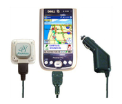
Pharos Science iGPS-360

$50.00 to $134.00


Compatible with most Pocket PCs with a CompactFlash slot, the Pharos Pocket GPS Navigator with CompactFlash inlcludes Pharos' iGPS-360 convertible receiver with a CompactFlash adaptor.Use it directly connected to the CompactFlash Adaptor, or for added flexibilty use the CF extension cable for placement and reception.Threre is no need for an external antenna!With Ostia, Pharos' award-winning navigation software installed on your Pocket PC, you can drive or walk through any city in the US, and locate your current position or quickly find a destination or point of interest. Routes can be calculated and viewed. The automated voice prompts will instruct you when and where to turn. If by chance you go "off-route," the automated voice will give an off-route warning and the system will automatically reroute you to your destination from your current position. Minimize

Manufacturer:Pharos Science Product MPNKey FeaturesOther FeaturesGPS SystemMiscellaneous
MPNREC20
GPS Type   Handheld (Outdoor)
Form FactorPlug-in
Enhanced accuracyWAAS enabled, EGNOS enabled
Receiver Type12 Channels
PC InterfaceUSB, Serial RS-232, Bluetooth
AntennaBuilt-in
Accuisition Time - Cold60 sec
Accuisition Time - Initial Time40 sec
Accuisition Time - Hot5 sec
Max. Horizontal accuracy   Dimensions
Width1.93 in.
Depth0.63 in.
Height2.17 in.
Weight0.09 lb.
UPC818948001382


Tags:

pharos, science, igps-360,


Interphase Corporation Chart Master V6i


One of the first things a boater will notice about the Chart Master V6 series is their vertically oriented high-definition (234x320 pixel) six-inch super-bright color LCD displays. They provide clear visibility even in full sunlight, and the Chart Master V6I, with it's built-in GPS antenna is a great choice for boats with open cockpits, center consoles and flying bridges and can serve well as a back-up unitMinimize


Garmin GPSMAP 76CSx


Safely find your way through the great outdoors with the Garmin GPSMAP 76CSx. Sporting a highly sensitive GPS receiver, the GPSMAP 76CSx can quickly and accurately chart a course through the wilderness without being impeded by dense tree cover or deep canyons. An included barometric altimeter and electronic compass give you an unprecedented level of accuracy over pinpointing your location and with the bright, color TFT display you can easily distinguish details on the screen, even while viewing in direct sunlight. The GPSMAP 76CSx is also fully waterproof and even floats in water.Minimize


Garmin GPSMAP 276C


This portable GPS navigator features a 256-color TFT display that's easy to read in bright sun along with a built-in basemap and auto routing to provide you with turn-by-turn directions to the marina for a day of boating.


Furuno GP7000F NT


The GP-7000F/NT is a GPS/WAAS plotter designed for a variety of vessels desiring video plotting and echo sounding capabilities. With the GP-7000 series, you can see the highly accurate position of your boat on the chart. The GP-7000 series has four display modes: Course Plot, Nav Data, Steering, and Highway modes. The course plot mode is useful for obtaining general information about surrounding sea areas. The Nav data mode clearly shows important navigational information with large text, which is easy to see even from a distance. The steering mode and highway mode assist the operator in following a predetermined route.Minimize