GlobalSat BT-359$40.00 to $90.00
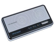
The GlobalSat BT-359 Bluetooth GPS receiver is our solution of the line Bluetooth GPS, which have both stylish and functional in true GlobalSat tradition. Taking its design criteria from the market leading BT-338 we have pushed the limits of GPS even further with greater sensitivity, more accuracy, and longer battery life than ever beforeMinimize
Manufacturer:GlobalSat Product MPN MPN | BT-359 | Key Features GPS Type | Handheld (Outdoor) | Form Factor | Wireless Receiver Module | Enhanced accuracy | WAAS enabled, EGNOS enabled | Receiver Type | 20 Channels | Other Features PC Interface | NMEA-0183, Bluetooth | Antenna | Built-in | GPS System Accuisition Time - Cold | 42 sec | Accuisition Time - Initial Time | 38 sec | Accuisition Time - Hot | 1 sec | Max. Horizontal accuracy | Battery | Battery Type and Quantity | Proprietary Lithium | Battery Life | 11 Hours | Dimensions Width | 3.23 in. | Depth | 0.53 in. | Height | 1.61 in. | Miscellaneous UPC | 4043619603046 |
Tags:globalsat, bt-359,
| Garmin GPSMAP 276C$615.00 to $1,000.00
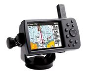
This portable GPS navigator features a 256-color TFT display that's easy to read in bright sun along with a built-in basemap and auto routing to provide you with turn-by-turn directions to the marina for a day of boating.
Manufacturer:Garmin Product MPN MPN | 010-00331-00 | Key Features GPS Type | Automobile | Form Factor | Fixed | Map capabilities | Internal, Map cartridges / Data cards | Enhanced accuracy | WAAS enabled | Input Method | Keypad | Receiver Type | 12 Channels | Display Display Size | 3.8 in. | Display Type | 256 Color LCD TFT Display | Resolutions | 480 X 320 | Technical Features Marine Features | Chart Plotter | Audible Features | Proximity Alarm, Anchor Alarm, Arrival Alarm, Off-Course Alarm, Clock Alarm | Trip calculator | Points-of-Interest (POI) | Included Software/Maps | North America Maps, Canada Maps, Europe Maps | Grids | Lat/Lon, MGRS, User Grid, UTM, Loran TD position format, Maidenhead | Other Features PC Interface | USB | Environmental Protection | IPX7 Waterproof Standard | Antenna | Quadrifilar Helix | GPS System Accuisition Time - Cold | 45 sec | Accuisition Time - Initial Time | 15 sec | Update rate | 1 per second, continuous | Max. Horizontal accuracy | | Enhanced position accuracy | | Differential standards | DGPS Ready | Number of routes | 50 | Waypoints | 3000 | Battery Battery Type and Quantity | Proprietary Lithium | Battery Life | 15 Hours | Warranty Warranty | 1 Year | Dimensions Width | 5.7 in. | Depth | 1.9 in. | Height | 3.2 in. | Weight | 0.85 lb. | Miscellaneous Family Line | Garmin GPSMAP | UPC | 839438266340 |
Tags:garmin, gpsmap, 276c,
| Garmin eTrex Legend$110.00 to $270.00
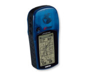
With the eTrex Legend, GARMIN has loaded a full basemap of North and South America into one small unit. The Legend is also designed to provide precise GPS positioning using correction data obtained from the Wide Area Augmentation System (WAAS). This product will provide position accuracy to less than three meters when receiving WAAS corrections.Minimize
Manufacturer:Garmin Product MPN MPN | ETREX LEGEND | Key Features GPS Type | Handheld (Outdoor) | Form Factor | Handheld | Map capabilities | Internal, Download maps | Enhanced accuracy | WAAS enabled | Input Method | Thumb Stick | Receiver Type | 12 Channels | Screen Size | 2.4 in. | Display Display Size | 1.1 in. x 2.1 in. | Display Type | LCD Display | Technical Features Special Features | Waypoint Icons | Trip calculator | Maximum speed, Current speed, Trip Timers, Time of sunrise/sunset, Track Log, Points-of-Interest (POI) | Included Software/Maps | Marine Cartography, City Navigation Maps, North America Maps, Europe Maps, Australia Maps, South Africa Maps, South America Maps, Middle East Maps, Asia Maps | Grids | Lat/Lon, MGRS, UTM, Loran TD position format, Maidenhead | Other Features PC Interface | Serial RS-232, NMEA-0183 | Built in memory | 8 MB | Environmental Protection | IPX7 Waterproof Standard | Antenna | Built-in | GPS System Accuisition Time - Cold | 45 sec | Accuisition Time - Initial Time | 15 sec | Update rate | 1 per second, continuous | Max. Horizontal accuracy | | Enhanced position accuracy | | Differential standards | DGPS Ready | Number of routes | 20 | Waypoints | 1000 | Battery Battery Type and Quantity | 2 x AA Batteries | Battery Life | 18 Hours | Warranty Warranty | 1 Year | Dimensions Width | 2 in. | Depth | 1.2 in. | Height | 4.4 in. | Weight | 0.33 lb. | Miscellaneous Family Line | Garmin eTrex | UPC | 753759030186 |
Tags:garmin, etrex, legend,
|

StreetPilot c530 comes ready to go right out of the box with preloaded City Navigator® NT street maps and a hefty points of interest (POIs) database, including motels, restaurants, fuel, ATMs and more. Simply touch the super-bright sunlight-readable color screen to enter a destination, and the c530 takes you there with 2D or 3D maps and turn-by-turn voice directions. In addition, the c530 accepts custom points of interest (POIs) such as school zones and safety cameras and lets you set proximity alerts to warn you of upcoming POIs.Minimize

Rugged, lightweight Edge attaches easily to the stem or handlebars of your bike with the included bike mount. Just turn it on, acquire GPS satellites and go. Edge 305 automatically measures your speed, distance, time, calories burned, altitude, climb and descent, and also records the route you have taken for review. For extra-precise climb and descent data, Edge 305 also incorporates a barometric altimeter to pinpoint changes in elevation.Minimize
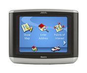
Magellan Maestro 3100 offers simple, sophisticated GPS navigation that's remarkably affordable. The most intuitive graphical 3.5" touch-screen interface available makes navigation easy. Enter virtually any destination and get turn-by-turn voice guidance to locations all over the contiguous United States. Smart touch-icons and Magellan's unique QuickSpell function enable error-free spelling, minimizing steps, so you get a customized route to your destination with just a few touches of the screen. Hundreds of thousands of preprogrammed points of interest make it easy to find restaurants, gas stations, ATM and more. Minimize

The new GP37 DGPS/WAAS Navigator is compact in size, yet big on power, features and performance. This waterproof unit is perfect for a wide range of boats. It is equipped with a WAAS and a DGPS receiver as standard supply. It utilizes both WAAS and differential radio beacon correction methods to give you the most accurate position fix available. The GP37 offers extremely accurate position fixes -- 10m for basic GPS, 5m or better with DGPS and 3m or better where WAAS service is available. It should be noted that DGPS is more reliable and accurate, as the WAAS system is still currently under development. There is no guarantee of accuracy, integrity, continuity or availability of the WAAS signal. For that reason, the GP37 runs with DGPS as the default setting in auto selection mode. In this mode, if the DGPS signal can not be received for any reason, the WAAS mode is automatically selected. Manual setting is also available. The display modes include Plotter, two Customizable displays, Steering, Highway and SpeedMinimize