Garmin eTrex Legend$110.00 to $270.00
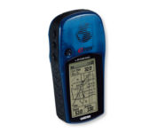
With the eTrex Legend, GARMIN has loaded a full basemap of North and South America into one small unit. The Legend is also designed to provide precise GPS positioning using correction data obtained from the Wide Area Augmentation System (WAAS). This product will provide position accuracy to less than three meters when receiving WAAS corrections.Minimize
Manufacturer:Garmin Product MPN MPN | ETREX LEGEND | Key Features GPS Type | Handheld (Outdoor) | Form Factor | Handheld | Map capabilities | Internal, Download maps | Enhanced accuracy | WAAS enabled | Input Method | Thumb Stick | Receiver Type | 12 Channels | Screen Size | 2.4 in. | Display Display Size | 1.1 in. x 2.1 in. | Display Type | LCD Display | Technical Features Special Features | Waypoint Icons | Trip calculator | Maximum speed, Current speed, Trip Timers, Time of sunrise/sunset, Track Log, Points-of-Interest (POI) | Included Software/Maps | Marine Cartography, City Navigation Maps, North America Maps, Europe Maps, Australia Maps, South Africa Maps, South America Maps, Middle East Maps, Asia Maps | Grids | Lat/Lon, MGRS, UTM, Loran TD position format, Maidenhead | Other Features PC Interface | Serial RS-232, NMEA-0183 | Built in memory | 8 MB | Environmental Protection | IPX7 Waterproof Standard | Antenna | Built-in | GPS System Accuisition Time - Cold | 45 sec | Accuisition Time - Initial Time | 15 sec | Update rate | 1 per second, continuous | Max. Horizontal accuracy | | Enhanced position accuracy | | Differential standards | DGPS Ready | Number of routes | 20 | Waypoints | 1000 | Battery Battery Type and Quantity | 2 x AA Batteries | Battery Life | 18 Hours | Warranty Warranty | 1 Year | Dimensions Width | 2 in. | Depth | 1.2 in. | Height | 4.4 in. | Weight | 0.33 lb. | Miscellaneous Family Line | Garmin eTrex | UPC | 753759030186 |
Tags:garmin, etrex, legend,
| Garmin Forerunner 205$128.00 to $413.00
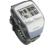
The Forerunner 205 sports a unique design that wraps the GPS antenna around part of the wrist for a better view of the sky, and its high sensitivity GPS receiver can track under trees and near tall buildings.
Manufacturer:Garmin Product MPN MPN | 010-00466-00 | Key Features GPS Type | Handheld (Outdoor) | Form Factor | Handheld | Input Method | Keypad | Screen Size | 1.5 in. | Display Display Size | 1.3 in. x 0.8 in. | Display Type | LCD Display | Resolutions | 160 X 100 | Technical Features Special Features | Training Computer, 3D Map View | Trip calculator | Maximum speed, Current speed, Trip Timers, Elevation Computer, Time of sunrise/sunset | Other Features PC Interface | USB | Environmental Protection | IPX7 Waterproof Standard | Antenna | Built-in | GPS System Accuisition Time - Cold | 45 sec | Accuisition Time - Initial Time | 38 sec | Accuisition Time - Hot | 1 sec | Update rate | 1 per second, continuous | Max. Horizontal accuracy | | Number of routes | 50 | Waypoints | 100 | Battery Battery Type and Quantity | Proprietary Lithium | Battery Life | 10 Hours | Warranty Warranty | 1 Year | Dimensions Width | 2.1 in. | Depth | 2.7 in. | Height | 0.7 in. | Weight | 0.17 lb. | Miscellaneous Family Line | Garmin Forerunner | UPC | 753759051914 |
Tags:garmin, forerunner, 205,
| Garmin GPSMAP 3205$520.00 to $1,095.00
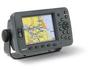
Plug into the power of the Garmin Marine network with the Garmin 3200 series. Rugged, waterproof, and easy to install, these chartplotters come preloaded with Garmin's detail-rich marine cartography utilizing BlueChart® g2 technology.
Manufacturer:Garmin Product MPN MPN | 010-00526-00 | Key Features GPS Type | Marine | Form Factor | Fixed | Map capabilities | Internal, Map cartridges / Data cards | Enhanced accuracy | WAAS enabled | Input Method | Keypad | Receiver Type | 12 Channels | Display Display Size | 5 in. | Display Type | 256 Color LCD TFT Display | Resolutions | 640 X 480 | Technical Features Marine Features | Chart Plotter | Special Features | 3D Map View | Audible Features | Proximity Alarm, Anchor Alarm, Arrival Alarm, Off-Course Alarm, Clock Alarm, Low Battary/Voltage Alarm | Included Software/Maps | Marine Cartography | Other Features PC Interface | NMEA-0183 | Environmental Protection | IPX7 Waterproof Standard | GPS System Accuisition Time - Cold | 45 sec | Accuisition Time - Initial Time | 15 sec | Update rate | 1 per second, continuous | Max. Horizontal accuracy | | Enhanced position accuracy | | Differential standards | DGPS Ready | Number of routes | 50 | Waypoints | 4000 | Warranty Warranty | 1 Year | Dimensions Width | 7.8 in. | Depth | 3 in. | Height | 4.7 in. | Weight | 1.8 lb. | Miscellaneous Family Line | Garmin GPSMAP | UPC | 753759053048 |
Tags:garmin, gpsmap, 3205,
|

No matter where your outdoor activities take you, the Rino® 530 keeps you on track and in touch. Similar to the 520, this rugged, two-way radio with GPS packs a bold color display, 14-mile communication range, and turn-by-turn directions - giving you peace of mind in the great outdoors. Taking it a step further, the Rino 530 adds an electronic compass, barometric altimeter, and NOAA weather receiver, making it a favorite with hikers and climbers.Minimize
The handheld mapping GPS designed by hunters for hunters lets you follow the big game in color with 16-channel GPS precision. The iFINDER® Hunt C with color display offers everything you'd expect in a versatile, precision mapping GPS unit made for the field, including hunting-specific icons, unique "Scout Mode", electronic compass, barometric altimeter, built-in microphone, and more.Minimize

The Dual XNA3550 features an easy to use touch screen graphic interface with MP3 playback capability. Turn-by-turn instructions with voice guidance. Visual left/right LED indicators. 3D Map view. Level selectable map view. Start route guidance search by:- Address/intersection- Points of interest- Address book- Recent destination. GPS status indicator.Minimize

Rugged, lightweight Edge attaches easily to the stem or handlebars of your bike with the included bike mount. Just turn it on, acquire GPS satellites and go. Edge 305 automatically measures your speed, distance, time, calories burned, altitude, climb and descent, and also records the route you have taken for review. For extra-precise climb and descent data, Edge 305 also incorporates a barometric altimeter to pinpoint changes in elevation.Minimize