Garmin Forerunner 305$147.00 to $390.00
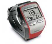
Get the most out of your workouts with the Garmin Forerunner 305, a GPS personal trainer. Whether you’re going for a daily jog or training for a triathlon, the Forerunner 305 tracks and stores vital information that you can analyze on your computer with interactive graphs that chart your pace, time, distance traveled, and heart rate. Upload your information to MotionBased.com, Garmin’s web-based application that allows you to track your fitness statistics online, giving you the tools you need to take your training to the next level.Minimize
Manufacturer:Garmin Product MPN MPN | 010-00467-02 | Key Features GPS Type | Handheld (Outdoor) | Form Factor | Handheld | Screen Size | 1.5 in. | Display Display Size | 1.3 in. x 0.8 in. | Display Type | 4 Level Grayscale LCD Display | Resolutions | 160 X 100 | Technical Features Special Features | Heart Rate Monitor, 3D Map View | Trip calculator | Trip Timers | Other Features PC Interface | USB | Environmental Protection | IPX7 Waterproof Standard | Antenna | Built-in | GPS System Accuisition Time - Cold | 45 sec | Accuisition Time - Initial Time | 38 sec | Accuisition Time - Hot | 1 sec | Update rate | 1 per second, continuous | Max. Horizontal accuracy | Battery | Battery Type and Quantity | Proprietary Lithium | Battery Life | 10 Hours | Warranty Warranty | 1 Year | Dimensions Width | 2.1 in. | Depth | 2.7 in. | Height | 0.7 in. | Weight | 0.17 lb. | Miscellaneous Family Line | Garmin Forerunner | UPC | 740617010879 |
Tags:garmin, forerunner, 305,
| Navman NavPix N40i$80.00 to $230.00
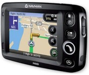
The N40i includes an integrated digital camera for taking NavPix to create an unmistakeable reminder of your chosen destination. So you can find your way there - no matter how far away it is – whenever you want.
Manufacturer:Navman Product MPN MPN | N40i | Key Features GPS Type | Automobile | Input Method | Touch Screen | Display Display Size | 3.5 in. | Display Type | LCD Display | Technical Features Audible Features | Voice Navigation Instructions | Included Software/Maps | USA Maps, Europe Maps, Australia Maps, Ireland | Other Features PC Interface | USB 1.1 | Built in memory | 64 MB | GPS System Update rate | 1 per second, continuous | Battery Battery Type and Quantity | Rechargeable Li-Ion Battery | Battery Life | 5 Hours | Dimensions Width | 4.65 in. | Depth | 0.89 in. | Height | 3.19 in. | Weight | 0.44 lb. | Miscellaneous UPC | 817186001376 |
Tags:navman, navpix, n40i,
| Interphase Corporation Chart Master V6i$531.00 to $573.00

One of the first things a boater will notice about the Chart Master V6 series is their vertically oriented high-definition (234x320 pixel) six-inch super-bright color LCD displays. They provide clear visibility even in full sunlight, and the Chart Master V6I, with it's built-in GPS antenna is a great choice for boats with open cockpits, center consoles and flying bridges and can serve well as a back-up unitMinimize
Manufacturer:Interphase Corporation Product MPN MPN | U1CHRTV6I | Key Features GPS Type | Marine | Form Factor | Fixed | Map capabilities | Internal, Map cartridges / Data cards | Enhanced accuracy | WAAS enabled | Input Method | Keypad, Thumb Stick | Receiver Type | 12 Channels | Display Display Size | 5.7 in. | Display Type | 256 Color LCD TFT Display | Resolutions | 234 X 320 | Technical Features Marine Features | Tide Prediction, Depth Display, Chart Plotter, Sonar / Sounder, MOB (Man Over Board) | Special Features | Waypoint Icons, Compass | Audible Features | Shallow/Deep Alarm | Included Software/Maps | Marine Cartography | Grids | Lat/Lon | Other Features PC Interface | USB, NMEA-0183, NMEA-0180 | Antenna | Built-in | GPS System Accuisition Time - Cold | 45 sec | Accuisition Time - Hot | 8 sec | Update rate | 1 per second, continuous | Enhanced position accuracy | | Number of routes | 25 | Waypoints | 500 | Warranty Warranty | 5 Years | Dimensions Width | 3.38 in. | Depth | 2 in. | Height | 4.5 in. | Weight | 2 lb. | Miscellaneous UPC | 027037002692 |
Tags:interphase, corporation, chart, master, v6i,
|

The GPS 76 is designed to provide precise GPS positioning using correction data obtained from the Wide Area Augmentation System (WAAS). This unit features a built-in quad helix antenna for superior reception and can provide position accuracy to less than three meters when receiving WAAS corrections.The GPS 76 provides 1 megabyte of internal user memory to be used for storing downloaded Points of Interest data. This 1 megabyte of storage area is preloaded from the factory with worldwide cities (populations greater than 200,000) and nautical navigation aids such as lights, buoys, sound signals and day beacons, and is perfect for downloading points of interest detail from GARMIN's line of MapSource CD-ROMs. The GPS 76 is also preloaded with tide data for the United States.Minimize

The GPS 72 is a low-cost solution for land or marine navigation designed to provide precise GPS positioning using correction data obtained from the Wide Area Augmentation System (WAAS). The GPS 72 can provide position accuracy to less than three meters when receiving WAAS corrections. This rugged, waterproof, unsinkable GPS receiver offers a large, 4-level grayscale screen. It's designed as the next generation in basic, entry-level GARMIN GPS.Minimize
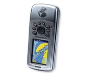
Safely find your way through the great outdoors with the Garmin GPSMAP 76CSx. Sporting a highly sensitive GPS receiver, the GPSMAP 76CSx can quickly and accurately chart a course through the wilderness without being impeded by dense tree cover or deep canyons. An included barometric altimeter and electronic compass give you an unprecedented level of accuracy over pinpointing your location and with the bright, color TFT display you can easily distinguish details on the screen, even while viewing in direct sunlight. The GPSMAP 76CSx is also fully waterproof and even floats in water.Minimize

This preloaded, offshore chartplotter combines the power of networking with brilliant color and slim-line design. The GPSMAP 4212 has preloaded BlueChart® g2 maps of the U.S. coast and displays them on a whopping 12.1” XGA display with crisp, video-quality resolution. By connecting to the Garmin Marine Network, you can add sonar, radar and weather. For even more enhanced features, you can add the optional Bluechart g2 Vision card.Minimize