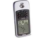
Garmin GPSMAP 76Cx$233.00 to $432.00

The GPSMAP 76CSx is a refreshing upgrade of the GPSMAP 76CS, one of our most popular models for outdoor and marine use. This unit features a removable microSD card for detailed mapping memory and a waterproof, rugged housing. The microSD card slot is located inside the waterproof battery compartment. Users can load map data and transfer routes and waypoints through the unit’s fast USB connection.Minimize
Manufacturer:Garmin Product MPN MPN | 010-00468-00 | Key Features GPS Type | Marine | Form Factor | Handheld | Map capabilities | Internal | Enhanced accuracy | WAAS enabled | Receiver Type | 12 Channels | Screen Size | 2.7 in. | Display Display Size | 1.5 in. x 2.2 in. | Display Type | 256 Color LCD TFT Display | Resolutions | 160 X 240 | Technical Features Marine Features | Fishing Calcluator, MOB (Man Over Board) | Special Features | Waypoint Icons | Audible Features | Proximity Alarm, Anchor Alarm, Arrival Alarm, Off-Course Alarm, Clock Alarm, Shallow/Deep Alarm | Trip calculator | Moving average, Total average, Odometer, Time of sunrise/sunset, Track Log, Points-of-Interest (POI) | Included Software/Maps | North America Maps, South America Maps | Grids | Lat/Lon, MGRS, User Grid, UTM, Loran TD position format, Maidenhead | Other Features PC Interface | USB, NMEA-0183 | Environmental Protection | IPX7 Waterproof Standard, High Impact Plastic Alloy Body | Antenna | Built-in, Quadrifilar Helix | GPS System Accuisition Time - Cold | 38 sec | Accuisition Time - Initial Time | 1 sec | Update rate | 1 per second, continuous | Max. Horizontal accuracy | | Enhanced position accuracy | | Differential standards | DGPS Ready | Number of routes | 50 | Waypoints | 1000 | Battery Battery Type and Quantity | 2 x AA Batteries | Battery Life | 18 Hours | Warranty Warranty | 1 Year | Dimensions Width | 2.7 in. | Depth | 1.4 in. | Height | 6.2 in. | Weight | 0.48 lb. | Miscellaneous Family Line | Garmin GPSMAP | UPC | 753759051631 |
Tags:garmin, gpsmap, 76cx,
| Bushnell NAV500$164.00 to $285.00

Bushnell has announced their entry into the portable auto GPS navigation market with the announcement of the Bushnell Nav 500. The Nav 500 offers many features found on other navigation devices in its class such as a 3.5 inch touch screen display, pre-installed maps of the USA and Canada, and an MP3 player.
Manufacturer:Bushnell Product MPN MPN | 36-5001 | Key Features GPS Type | Automobile | Form Factor | Fixed | Map capabilities | Internal, Map cartridges / Data cards, DVD | Enhanced accuracy | WAAS enabled | Input Method | Keypad, Touch Screen | Receiver Type | 20 Channels | Display Display Size | 3.5 in. | Display Type | LCD Display | Resolutions | 320 X 240 | Technical Features Marine Features | Split Screen | Special Features | Compass, MP3 Player | Audible Features | Voice Navigation Instructions | Trip calculator | Route Recalculation | Included Software/Maps | Canada Maps | Grids | Lat/Lon | Other Features PC Interface | USB, Bluetooth | Expansion Slot Type | SD (Secure Digital) Card Slot | Battery Battery Type and Quantity | Rechargeable Li-Ion Battery | Warranty Warranty | 1 Year | Dimensions Width | 5.63 in. | Depth | 0.91 in. | Height | 3 in. | Weight | 0.75 lb. | Miscellaneous UPC | 029757365002 |
Tags:bushnell, nav500,
| Magellan Maestro 3100$99.00 to $212.00

Magellan Maestro 3100 offers simple, sophisticated GPS navigation that's remarkably affordable. The most intuitive graphical 3.5" touch-screen interface available makes navigation easy. Enter virtually any destination and get turn-by-turn voice guidance to locations all over the contiguous United States. Smart touch-icons and Magellan's unique QuickSpell function enable error-free spelling, minimizing steps, so you get a customized route to your destination with just a few touches of the screen. Hundreds of thousands of preprogrammed points of interest make it easy to find restaurants, gas stations, ATM and more. Minimize
Manufacturer:Magellan Product MPN MPN | 980934-01 | Key Features GPS Type | Automobile | Form Factor | Fixed | Map capabilities | Map cartridges / Data cards | Receiver Type | 20 Channels | Display Display Type | 64k Colors LCD TFT Display | Resolutions | 320 X 240 | Technical Features Special Features | Waypoint Icons | Trip calculator | Route Recalculation, Detour Feature, Points-of-Interest (POI) | Included Software/Maps | USA Maps | Other Features Antenna | Built-in | GPS System Max. Horizontal accuracy | Battery | Battery Life | 3 Hours | Dimensions Width | 4.3 in. | Depth | 1.1 in. | Height | 3.5 in. | Weight | 6.5 lb. | Miscellaneous UPC | 763357117226 |
Tags:magellan, maestro, 3100,
|


